Aberfeldy geodata
Aberfeldy (Scotland) is a populated place; located in United Kingdom in Europe/London (GMT+1) time zone. With population of 1,960 people, there are 2654 cities with bigger population in this country. Compared to other cities in United Kingdom, 96.9% of cities are located further ↓South; 86.5% of cities are located further →East and 67.1% of cities have lower elevation than Aberfeldy. Note1


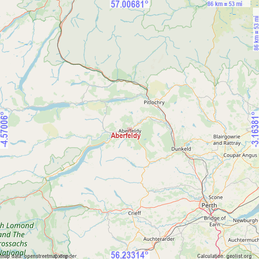
Aberfeldy GPS coordinates[2]
56° 37' 19.056" North, 3° 52' 0.948" West
| Map corner | latitude | longitude |
|---|---|---|
| Upper-left | 57.00681°, | -4.57006° |
| Center: | 56.62196°, | -3.86693° |
| Lower-right: | 56.23314°, | -3.16381° |
| Map W x H: | 86×86 km | = 53.4×53.4mi |
| max Lat: | 60.39635° ⇑3.1% North |
| Aberfeldy: | 56.62196° |
| min Lat: | ⇓96.9% South 34.60088° |
| min Long | Aberfeldy | max Long |
| -7.64133° | -3.86693° | 32.95536° |
| W 13.5%⇐ | ⇒86.5% E |
Elevation
Elevation of Aberfeldy is 90 m = 295 ft, and this is 17.1 m = 56 ft above average elevation for this country.
| Max E: |
515 m = 1690 ft | 32.9% |
| Aberfeldy | 90 m 295 ft | |
| Avg. | 72.9 m = 239 ft | |
Min E: |
-30 m = -98 ft | 67.1% |
See also: United Kingdom elevation on elevation.city.
Geographical zone
Aberfeldy is located in North temperate zone (between Tropic of Cancer and the Arctic Circle). Distance of this North polar circle is 1105.4 km =686.9 mi to North.| Distance of | km | miles | from Aberfeldy |
|---|---|---|---|
| North Pole | 3711.3 | 2306.1 | to North |
| Arctic Circle | 1105.4 | 686.9 | to North |
| Tropic Cancer | 3689.9 | 2292.8 | to South |
| Equator | 6295.8 | 3912 | to South |


Nearby cities:
15 places around Aberfeldy: (largest is in red/bold)
• Almondbank
31.3 km =19.4 mi,  136°
136°
• Bankfoot
25.3 km =15.7 mi,  122°
122°
• Blairgowrie
32.4 km =20.1 mi,  95°
95°
• Burrelton
36.4 km =22.6 mi,  107°
107°
• Comrie
29 km =18 mi,  193°
193°
• Crieff
27.8 km =17.3 mi,  176°
176°
• Killin
32.5 km =20.2 mi,  237°
237°
• Luncarty
30.7 km =19.1 mi,  127°
127°
• Methven
28.8 km =17.9 mi, 142°
• Murthly
26.6 km =16.5 mi, 112°
• Muthill
32.3 km =20.1 mi, 176°
• Perth
36.7 km =22.8 mi, 133°
• Pitlochry
12.3 km =7.6 mi,  41°
41°
• Scone
36.2 km =22.5 mi, 128°
• Stanley
29.6 km =18.4 mi, 120°
Sources, notices
• [Note1] Compared only with cities in United Kingdom existing in our database
• [Src1] Map data: © OpenStreetMap contributors (CC-BY-SA)
• [Src2] Other city data from geonames.org with taken over terms of usage.
• [Src3] Geographical zone / Annual Mean Temperature by Robert A. Rohde @ Wikipedia
