Newtonmore geodata
Newtonmore (Scotland) is a populated place; located in United Kingdom in Europe/London (GMT+1) time zone. With population of 1,100 people, there are 3491 cities with bigger population in this country. Compared to other cities in United Kingdom, 97.4% of cities are located further ↓South; 89.7% of cities are located further →East and 99% of cities have lower elevation than Newtonmore. Note1


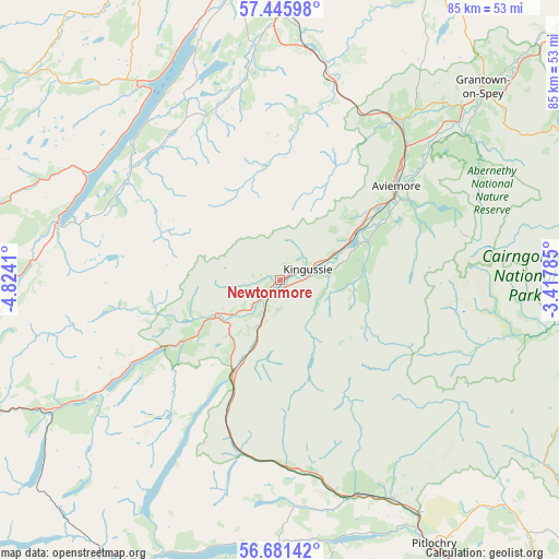
Newtonmore GPS coordinates[2]
57° 3' 56.412" North, 4° 7' 15.492" West
| Map corner | latitude | longitude |
|---|---|---|
| Upper-left | 57.44598°, | -4.8241° |
| Center: | 57.06567°, | -4.12097° |
| Lower-right: | 56.68142°, | -3.41785° |
| Map W x H: | 85×85 km | = 52.8×52.8mi |
| max Lat: | 60.39635° ⇑2.6% North |
| Newtonmore: | 57.06567° |
| min Lat: | ⇓97.4% South 34.60088° |
| min Long | Newtonmore | max Long |
| -7.64133° | -4.12097° | 32.95536° |
| W 10.3%⇐ | ⇒89.7% E |
Elevation
Elevation of Newtonmore is 249 m = 817 ft, and this is 176.1 m = 578 ft above average elevation for this country.
| Max E: |
515 m = 1690 ft | 1% |
| Newtonmore | 249 m 817 ft | |
| Avg. | 72.9 m = 239 ft | |
Min E: |
-30 m = -98 ft | 99% |
See also: United Kingdom elevation on elevation.city.
Geographical zone
Newtonmore is located in North temperate zone (between Tropic of Cancer and the Arctic Circle). Distance of this North polar circle is 1056.1 km =656.2 mi to North.| Distance of | km | miles | from Newtonmore |
|---|---|---|---|
| North Pole | 3662 | 2275.5 | to North |
| Arctic Circle | 1056.1 | 656.2 | to North |
| Tropic Cancer | 3739.2 | 2323.4 | to South |
| Equator | 6345.1 | 3942.7 | to South |


Nearby cities:
15 places around Newtonmore: (largest is in red/bold)
• Aviemore
22.9 km =14.2 mi,  50°
50°
• Boat of Garten
30.1 km =18.7 mi, 47°
• Culloden
46.9 km =29.1 mi,  358°
358°
• Drumnadrochit
36.9 km =22.9 mi,  324°
324°
• Fort Augustus
35 km =21.7 mi,  284°
284°
• Grantown on Spey
42.7 km =26.5 mi, 46°
• Highland
47.1 km =29.3 mi,  352°
352°
• Inverness
46.4 km =28.8 mi, 352°
• Kingussie
4.4 km =2.7 mi,  69°
69°
• Milton
38.2 km =23.7 mi, 322°
• Milton of Leys
43 km =26.7 mi, 355°
• Nethy Bridge
35.7 km =22.2 mi, 51°
• Pitlochry
46.5 km =28.9 mi,  149°
149°
• Smithton
46.1 km =28.6 mi, 357°
• Westhill
45.3 km =28.1 mi, 357°
Sources, notices
• [Note1] Compared only with cities in United Kingdom existing in our database
• [Src1] Map data: © OpenStreetMap contributors (CC-BY-SA)
• [Src2] Other city data from geonames.org with taken over terms of usage.
• [Src3] Geographical zone / Annual Mean Temperature by Robert A. Rohde @ Wikipedia
