Isle of North Uist geodata
Isle of North Uist (Scotland) is a populated locality; located in United Kingdom in Europe/London (GMT+1) time zone. With population of 1,271 people, there are 3271 cities with bigger population in this country. Compared to other cities in United Kingdom, 99.1% of cities are located further ↓South; 99.8% of cities are located further →East and 95.3% of cities have lower elevation than Isle of North Uist. Note1


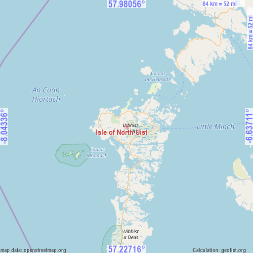
Isle of North Uist GPS coordinates[2]
57° 36' 20.916" North, 7° 20' 24.864" West
| Map corner | latitude | longitude |
|---|---|---|
| Upper-left | 57.98056°, | -8.04336° |
| Center: | 57.60581°, | -7.34024° |
| Lower-right: | 57.22716°, | -6.63711° |
| Map W x H: | 83.8×83.8 km | = 52.1×52.1mi |
| max Lat: | 60.39635° ⇑0.9% North |
| Isle of North Uist: | 57.60581° |
| min Lat: | ⇓99.1% South 34.60088° |
| min Long | Isle of North U | max Long |
| -7.64133° | -7.34024° | 32.95536° |
| W 0.2%⇐ | ⇒99.8% E |
Elevation
Elevation of Isle of North Uist is 187 m = 614 ft, and this is 114.1 m = 374 ft above average elevation for this country.
| Max E: |
515 m = 1690 ft | 4.7% |
| Isle of North Uist | 187 m 614 ft | |
| Avg. | 72.9 m = 239 ft | |
Min E: |
-30 m = -98 ft | 95.3% |
See also: United Kingdom elevation on elevation.city.
Geographical zone
Isle of North Uist is located in North temperate zone (between Tropic of Cancer and the Arctic Circle). Distance of this North polar circle is 996 km =618.9 mi to North.| Distance of | km | miles | from Isle of North Uist |
|---|---|---|---|
| North Pole | 3601.9 | 2238.1 | to North |
| Arctic Circle | 996 | 618.9 | to North |
| Tropic Cancer | 3799.2 | 2360.7 | to South |
| Equator | 6405.2 | 3980 | to South |


Nearby cities:
15 places around Isle of North Uist: (largest is in red/bold)
• Barra
69.9 km =43.4 mi,  185°
185°
• Benbecula
17.6 km =10.9 mi,  180°
180°
• Broadford
94.6 km =58.8 mi,  115°
115°
• Caol
159.6 km =99.2 mi, 122°
• Fort William
160.3 km =99.6 mi, 123°
• Isle Of Mull
159.9 km =99.4 mi,  143°
143°
• Isle of Lewis
88.4 km =54.9 mi,  39°
39°
• Isle of South Uist
40.1 km =24.9 mi, 179°
• Kyle of Lochalsh
103.8 km =64.5 mi,  110°
110°
• Mallaig
112.7 km =70 mi,  126°
126°
• Portree
71.7 km =44.6 mi, 107°
• Sandwick
88.3 km =54.9 mi, 41°
• Stornoway
87.6 km =54.4 mi, 40°
• Tobermory
133.5 km =83 mi,  145°
145°
• Ullapool
133.4 km =82.9 mi,  75°
75°
Sources, notices
• [Note1] Compared only with cities in United Kingdom existing in our database
• [Src1] Map data: © OpenStreetMap contributors (CC-BY-SA)
• [Src2] Other city data from geonames.org with taken over terms of usage.
• [Src3] Geographical zone / Annual Mean Temperature by Robert A. Rohde @ Wikipedia
