Gagra geodata
Gagra (Abkhazia) is a seat of a second-order administrative division; located in Georgia in Asia/Tbilisi (GMT+4) time zone. With population of 8,266 people, there are 41 cities with bigger population in this country. Compared to other cities in Georgia, 99.1% of cities are located further ↓South; 99.1% of cities are located further →East and 91.5% of cities have higher elevation than Gagra. Note1


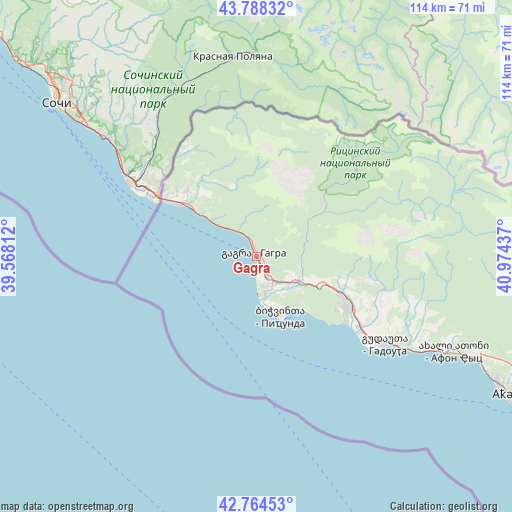
Gagra GPS coordinates[2]
43° 16' 42.888" North, 40° 16' 16.464" East
| Map corner | latitude | longitude |
|---|---|---|
| Upper-left | 43.78832°, | 39.56812° |
| Center: | 43.27858°, | 40.27124° |
| Lower-right: | 42.76453°, | 40.97437° |
| Map W x H: | 113.8×113.8 km | = 70.7×70.7mi |
| max Lat: | 43.38111° ⇑0.9% North |
| Gagra: | 43.27858° |
| min Lat: | ⇓99.1% South 41.21725° |
| min Long | Gagra | max Long |
| 40.07944° | 40.27124° | 46.27667° |
| W 0.9%⇐ | ⇒99.1% E |
Elevation
Elevation of Gagra is 11 m = 36 ft, and this is 567.8 m = 1863 ft below average elevation for this country.
| Max E: |
2223 m = 7293 ft | 91.5% |
| Avg. | 578.8 m = 1899 ft | |
| Gagra | 11 m = 36 ft | |
Min E: |
1 m = 3 ft | 8.5% |
See also: Georgia elevation on elevation.city.
Geographical zone
Gagra is located in North temperate zone (between Tropic of Cancer and the Arctic Circle). Distance of this Northern Tropic circle is 2206.2 km =1370.9 mi to South.| Distance of | km | miles | from Gagra |
|---|---|---|---|
| North Pole | 5194.9 | 3228 | to North |
| Arctic Circle | 2589 | 1608.7 | to North |
| Tropic Cancer | 2206.2 | 1370.9 | to South |
| Equator | 4812.1 | 2990.1 | to South |


Nearby cities:
15 places around Gagra: (largest is in red/bold)
• Bich’vinta
14.1 km =8.8 mi,  156°
156°
• Dranda
84.7 km =52.6 mi,  122°
122°
• Gali
139.7 km =86.8 mi, 121°
• Gantiadi
19.3 km =12 mi,  306°
306°
• Gudauta
34.2 km =21.3 mi, 124°
• Gulrip’shi
77.6 km =48.2 mi, 120°
• Kelasuri
72.9 km =45.3 mi, 117°
• Likhni
31.4 km =19.5 mi, 117°
• Mokvi
111.1 km =69 mi, 117°
• Och’amch’ire
116 km =72.1 mi, 122°
• Orsant’ia
145.6 km =90.5 mi,  128°
128°
• P’rimorsk’oe
40.2 km =25 mi, 120°
• Sokhumi
65.6 km =40.8 mi, 117°
• Stantsiya Novyy Afon
51 km =31.7 mi, 115°
• Tqvarch'eli
124.4 km =77.3 mi,  113°
113°
Sources, notices
• [Note1] Compared only with cities in Georgia existing in our database
• [Src1] Map data: © OpenStreetMap contributors (CC-BY-SA)
• [Src2] Other city data from geonames.org with taken over terms of usage.
• [Src3] Geographical zone / Annual Mean Temperature by Robert A. Rohde @ Wikipedia
