Och’amch’ire geodata
Och’amch’ire (Abkhazia) is a seat of a second-order administrative division; located in Georgia in Asia/Tbilisi (GMT+4) time zone. With population of 15,517 people, there are 21 cities with bigger population in this country. Compared to other cities in Georgia, 86.3% of cities are located further ↓South; 90.6% of cities are located further →East and 97.4% of cities have higher elevation than Och’amch’ire. Note1


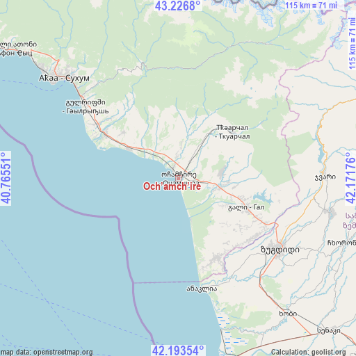
Och’amch’ire GPS coordinates[2]
42° 42' 44.352" North, 41° 28' 7.068" East
| Map corner | latitude | longitude |
|---|---|---|
| Upper-left | 43.2268°, | 40.76551° |
| Center: | 42.71232°, | 41.46863° |
| Lower-right: | 42.19354°, | 42.17176° |
| Map W x H: | 114.9×114.9 km | = 71.4×71.4mi |
| max Lat: | 43.38111° ⇑13.7% North |
| Och’amch’ire: | 42.71232° |
| min Lat: | ⇓86.3% South 41.21725° |
| min Long | Och’amch’ir | max Long |
| 40.07944° | 41.46863° | 46.27667° |
| W 9.4%⇐ | ⇒90.6% E |
Elevation
Elevation of Och’amch’ire is 5 m = 16 ft, and this is 573.8 m = 1883 ft below average elevation for this country.
| Max E: |
2223 m = 7293 ft | 97.4% |
| Avg. | 578.8 m = 1899 ft | |
| Och’amch’ire | 5 m = 16 ft | |
Min E: |
1 m = 3 ft | 2.6% |
See also: Georgia elevation on elevation.city.
Geographical zone
Och’amch’ire is located in North temperate zone (between Tropic of Cancer and the Arctic Circle). Distance of this Northern Tropic circle is 2143.2 km =1331.7 mi to South.| Distance of | km | miles | from Och’amch’ire |
|---|---|---|---|
| North Pole | 5257.9 | 3267.1 | to North |
| Arctic Circle | 2652 | 1647.9 | to North |
| Tropic Cancer | 2143.2 | 1331.7 | to South |
| Equator | 4749.2 | 2951 | to South |


Nearby cities:
15 places around Och’amch’ire: (largest is in red/bold)
• Dranda
31.2 km =19.4 mi,  304°
304°
• Gali
24 km =14.9 mi,  113°
113°
• Gulrip’shi
38.6 km =24 mi,  308°
308°
• Jvari
47.7 km =29.6 mi,  89°
89°
• Kelasuri
43.9 km =27.3 mi, 312°
• Khobi
56.5 km =35.1 mi,  141°
141°
• Kveda Chkhorots’q’u
57.5 km =35.7 mi,  116°
116°
• Mokvi
11.3 km =7 mi,  5°
5°
• Orsant’ia
32 km =19.9 mi,  148°
148°
• P’ot’i
65.1 km =40.5 mi,  165°
165°
• Sokhumi
51 km =31.7 mi, 309°
• Stantsiya Novyy Afon
65.7 km =40.8 mi, 308°
• Tqvarch'eli
22.4 km =13.9 mi,  50°
50°
• Tsalenjikha
50.5 km =31.4 mi,  103°
103°
• Zugdidi
39.9 km =24.8 mi, 124°
Sources, notices
• [Note1] Compared only with cities in Georgia existing in our database
• [Src1] Map data: © OpenStreetMap contributors (CC-BY-SA)
• [Src2] Other city data from geonames.org with taken over terms of usage.
• [Src3] Geographical zone / Annual Mean Temperature by Robert A. Rohde @ Wikipedia
