Upernavik geodata
Upernavik (Avannaata) is a populated place; located in Greenland in America/Godthab (GMT-2) time zone. With population of 1,129 people, there are 12 cities with bigger population in this country. Compared to other cities in Greenland, 94.4% of cities are located further ↓South; 94.4% of cities are located further →East and 100% of cities have higher elevation than Upernavik. Note1


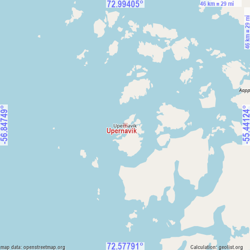
Upernavik GPS coordinates[2]
72° 47' 13.92" North, 56° 8' 39.696" West
| Map corner | latitude | longitude |
|---|---|---|
| Upper-left | 72.99405°, | -56.84749° |
| Center: | 72.7872°, | -56.14436° |
| Lower-right: | 72.57791°, | -55.44124° |
| Map W x H: | 46.3×46.3 km | = 28.8×28.8mi |
| max Lat: | 77.46666° ⇑5.6% North |
| Upernavik: | 72.7872° |
| min Lat: | ⇓94.4% South 60.14169° |
| min Long | Upernavik | max Long |
| -69.23155° | -56.14436° | -21.96221° |
| W 5.6%⇐ | ⇒94.4% E |
Elevation
Elevation of Upernavik is 1 m = 3 ft, and this is 31.1 m = 102 ft below average elevation for this country.
| Max E: |
242 m = 794 ft | 100% |
| Avg. | 32.1 m = 105 ft | |
| Upernavik | 1 m = 3 ft | |
Min E: |
1 m = 3 ft | 0% |
See also: Greenland elevation on elevation.city.
Geographical zone
Upernavik is located in North Frigid zone (between North Pole and Arctic Circle). Distance of this North polar circle is 692 km =430 mi to South.| Distance of | km | miles | from Upernavik |
|---|---|---|---|
| North Pole | 1913.9 | 1189.2 | to North |
| Arctic Circle | 692 | 430 | to South |
| Tropic Cancer | 5487.3 | 3409.6 | to South |
| Equator | 8093.2 | 5028.9 | to South |


Nearby cities:
15 places around Upernavik: (largest is in red/bold)
• Aasiaat
468.8 km =291.3 mi,  165°
165°
• Ilulissat
436.3 km =271.1 mi,  155°
155°
• Ittoqqortoormiit
1206.7 km =749.8 mi,  102°
102°
• Kangaatsiaq
507.9 km =315.6 mi, 168°
• Kangerlussuaq
674.8 km =419.3 mi, 162°
• Maniitsoq
829.5 km =515.4 mi, 171°
• Nuuk
972.9 km =604.5 mi, 169°
• Paamiut
1229.9 km =764.2 mi, 167°
• Qaanaaq
637.4 km =396.1 mi,  324°
324°
• Qasigiannguit
476.5 km =296.1 mi, 157°
• Qeqertarsuaq
404.7 km =251.5 mi, 166°
• Qeqertarsuaq
1215.4 km =755.2 mi, 167°
• Sisimiut
656.9 km =408.2 mi, 171°
• Tasiilaq
1072.8 km =666.6 mi,  137°
137°
• Uummannaq
273.4 km =169.9 mi,  149°
149°
Sources, notices
• [Note1] Compared only with cities in Greenland existing in our database
• [Src1] Map data: © OpenStreetMap contributors (CC-BY-SA)
• [Src2] Other city data from geonames.org with taken over terms of usage.
• [Src3] Geographical zone / Annual Mean Temperature by Robert A. Rohde @ Wikipedia
