Ittoqqortoormiit geodata
Ittoqqortoormiit is a populated place; located in Greenland in America/Scoresbysund (GMT-2) time zone. With population of 531 people, there are 18 cities with bigger population in this country. Compared to other cities in Greenland, 83.3% of cities are located further ↓South; 100% of cities are located further ←West and 94.4% of cities have lower elevation than Ittoqqortoormiit. Note1


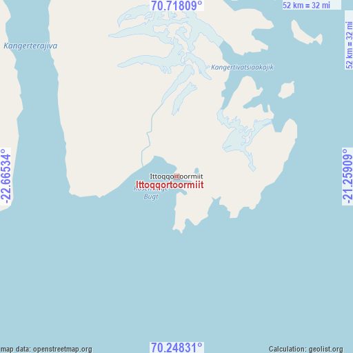
Ittoqqortoormiit GPS coordinates[2]
70° 29' 4.416" North, 21° 57' 43.956" West
| Map corner | latitude | longitude |
|---|---|---|
| Upper-left | 70.71809°, | -22.66534° |
| Center: | 70.48456°, | -21.96221° |
| Lower-right: | 70.24831°, | -21.25909° |
| Map W x H: | 52.2×52.2 km | = 32.4×32.4mi |
| max Lat: | 77.46666° ⇑16.7% North |
| Ittoqqortoormiit: | 70.48456° |
| min Lat: | ⇓83.3% South 60.14169° |
| min Long | Ittoqqortoormii | max Long |
| -69.23155° | -21.96221° | -21.96221° |
| W 100%⇐ | ⇒0% E |
Elevation
Elevation of Ittoqqortoormiit is 99 m = 325 ft, and this is 66.9 m = 219 ft above average elevation for this country.
| Max E: |
242 m = 794 ft | 5.6% |
| Ittoqqortoormiit | 99 m 325 ft | |
| Avg. | 32.1 m = 105 ft | |
Min E: |
1 m = 3 ft | 94.4% |
See also: Greenland elevation on elevation.city.
Geographical zone
Ittoqqortoormiit is located in North Frigid zone (between North Pole and Arctic Circle). Distance of this North polar circle is 436 km =270.9 mi to South.| Distance of | km | miles | from Ittoqqortoormiit |
|---|---|---|---|
| North Pole | 2169.9 | 1348.3 | to North |
| Arctic Circle | 436 | 270.9 | to South |
| Tropic Cancer | 5231.2 | 3250.5 | to South |
| Equator | 7837.1 | 4869.7 | to South |


Nearby cities:
15 places around Ittoqqortoormiit: (largest is in red/bold)
• Aasiaat
1200.6 km =746 mi,  260°
260°
• Ilulissat
1113.7 km =692 mi, 262°
• Kangaatsiaq
1241.3 km =771.3 mi, 258°
• Kangerlussuaq
1207.2 km =750.1 mi,  251°
251°
• Maniitsoq
1389.3 km =863.3 mi, 246°
• Narsaq
1512.8 km =940 mi,  225°
225°
• Nuuk
1434 km =891 mi,  241°
241°
• Qaqortoq
1530.1 km =950.8 mi, 225°
• Qasigiannguit
1133.7 km =704.4 mi, 260°
• Qeqertarsuaq
1202.3 km =747.1 mi, 263°
• Qeqertarsuaq
1530.1 km =950.8 mi, 232°
• Sisimiut
1321.9 km =821.4 mi, 252°
• Tasiilaq
842.9 km =523.8 mi, 230°
• Upernavik
1206.7 km =749.8 mi,  282°
282°
• Uummannaq
1103.9 km =685.9 mi,  271°
271°
Sources, notices
• [Note1] Compared only with cities in Greenland existing in our database
• [Src1] Map data: © OpenStreetMap contributors (CC-BY-SA)
• [Src2] Other city data from geonames.org with taken over terms of usage.
• [Src3] Geographical zone / Annual Mean Temperature by Robert A. Rohde @ Wikipedia
