Nema Kunku geodata
Nema Kunku (Western) is a populated place; located in Gambia in Africa/Banjul (GMT+0) time zone. With population of 815 people, there are 81 cities with bigger population in this country. Compared to other cities in Gambia, 95.1% of cities are located further ↑North; 78.9% of cities are located further →East and 55.3% of cities have higher elevation than Nema Kunku. Note1


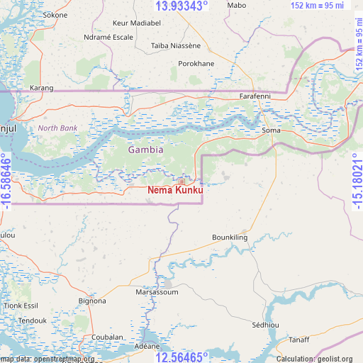
Nema Kunku GPS coordinates[2]
13° 15' 0" North, 15° 52' 59.988" West
| Map corner | latitude | longitude |
|---|---|---|
| Upper-left | 13.93343°, | -16.58646° |
| Center: | 13.25°, | -15.88333° |
| Lower-right: | 12.56465°, | -15.18021° |
| Map W x H: | 152.2×152.2 km | = 94.6×94.6mi |
| max Lat: | 13.8° ⇑95.1% North |
| Nema Kunku: | 13.25° |
| min Lat: | ⇓4.9% South 13.20194° |
| min Long | Nema Kunku | max Long |
| -16.73389° | -15.88333° | -13.85° |
| W 21.1%⇐ | ⇒78.9% E |
Elevation
Elevation of Nema Kunku is 18 m = 59 ft, and this is 3.1 m = 10 ft below average elevation for this country.
| Max E: |
49 m = 161 ft | 55.3% |
| Avg. | 21.1 m = 69 ft | |
| Nema Kunku | 18 m = 59 ft | |
Min E: |
1 m = 3 ft | 44.7% |
See also: Gambia elevation on elevation.city.
Geographical zone
Nema Kunku is located in North Torrid zone (between Equator and Tropic of Cancer). Distance of this Northern Tropic circle is 1132.7 km =703.8 mi to North.| Distance of | km | miles | from Nema Kunku |
|---|---|---|---|
| North Pole | 8533.8 | 5302.7 | to North |
| Arctic Circle | 5927.9 | 3683.4 | to North |
| Tropic Cancer | 1132.7 | 703.8 | to North |
| Equator | 1473.3 | 915.5 | to South |


Nearby cities:
15 places around Nema Kunku: (largest is in red/bold)
• Bajana
7.4 km =4.6 mi,  0°
0°
• Dumbutu
12.4 km =7.7 mi,  25°
25°
• Jali
14.3 km =8.9 mi,  320°
320°
• Jarrol
4.2 km =2.6 mi,  99°
99°
• Jifarong
5.8 km =3.6 mi,  17°
17°
• Jiroff
27.1 km =16.8 mi,  46°
46°
• Keneba
16.7 km =10.4 mi,  301°
301°
• Kuli Kunda
9.9 km =6.2 mi,  338°
338°
• Mayork
9.2 km =5.7 mi,  258°
258°
• Nioro
18.2 km =11.3 mi, 52°
• Sankandi
7.8 km =4.8 mi,  44°
44°
• Sibito
22 km =13.7 mi, 47°
• Sintet
7.4 km =4.6 mi, 104°
• Tankular
25 km =15.5 mi, 318°
• Wurokang
16.5 km =10.3 mi, 25°
Sources, notices
• [Note1] Compared only with cities in Gambia existing in our database
• [Src1] Map data: © OpenStreetMap contributors (CC-BY-SA)
• [Src2] Other city data from geonames.org with taken over terms of usage.
• [Src3] Geographical zone / Annual Mean Temperature by Robert A. Rohde @ Wikipedia
