Jali geodata
Jali (Lower River) is a populated place; located in Gambia in Africa/Banjul (GMT+0) time zone. With population of 1,024 people, there are 69 cities with bigger population in this country. Compared to other cities in Gambia, 81.3% of cities are located further ↑North; 82.1% of cities are located further →East and 81.3% of cities have lower elevation than Jali. Note1


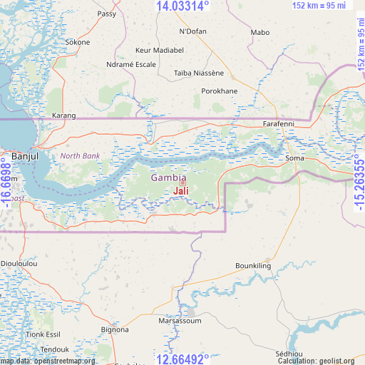
Jali GPS coordinates[2]
13° 21' 0" North, 15° 58' 0.012" West
| Map corner | latitude | longitude |
|---|---|---|
| Upper-left | 14.03314°, | -16.6698° |
| Center: | 13.35°, | -15.96667° |
| Lower-right: | 12.66492°, | -15.26355° |
| Map W x H: | 152.1×152.1 km | = 94.5×94.5mi |
| max Lat: | 13.8° ⇑81.3% North |
| Jali: | 13.35° |
| min Lat: | ⇓18.7% South 13.20194° |
| min Long | Jali | max Long |
| -16.73389° | -15.96667° | -13.85° |
| W 17.9%⇐ | ⇒82.1% E |
Elevation
Elevation of Jali is 31 m = 102 ft, and this is 9.9 m = 32 ft above average elevation for this country.
| Max E: |
49 m = 161 ft | 18.7% |
| Jali | 31 m 102 ft | |
| Avg. | 21.1 m = 69 ft | |
Min E: |
1 m = 3 ft | 81.3% |
See also: Gambia elevation on elevation.city.
Geographical zone
Jali is located in North Torrid zone (between Equator and Tropic of Cancer). Distance of this Northern Tropic circle is 1121.5 km =696.9 mi to North.| Distance of | km | miles | from Jali |
|---|---|---|---|
| North Pole | 8522.7 | 5295.8 | to North |
| Arctic Circle | 5916.8 | 3676.5 | to North |
| Tropic Cancer | 1121.5 | 696.9 | to North |
| Equator | 1484.4 | 922.4 | to South |


Nearby cities:
15 places around Jali: (largest is in red/bold)
• Bajana
9.7 km =6 mi,  112°
112°
• Dumbutu
14.4 km =8.9 mi,  90°
90°
• Gunjur
20.3 km =12.6 mi,  341°
341°
• Janneh Kunda
18.9 km =11.7 mi,  280°
280°
• Jarrol
17.6 km =10.9 mi,  131°
131°
• Jifarong
12.2 km =7.6 mi,  117°
117°
• Keneba
5.7 km =3.5 mi,  245°
245°
• Kerewan
20.4 km =12.7 mi,  319°
319°
• Kuli Kunda
5.7 km =3.5 mi, 108°
• Mayork
13 km =8.1 mi,  180°
180°
• Nema Kunku
14.3 km =8.9 mi,  140°
140°
• Saba
20.5 km =12.7 mi,  334°
334°
• Sankandi
15.5 km =9.6 mi, 111°
• Tankular
10.7 km =6.6 mi,  314°
314°
• Wurokang
16.6 km =10.3 mi,  77°
77°
Sources, notices
• [Note1] Compared only with cities in Gambia existing in our database
• [Src1] Map data: © OpenStreetMap contributors (CC-BY-SA)
• [Src2] Other city data from geonames.org with taken over terms of usage.
• [Src3] Geographical zone / Annual Mean Temperature by Robert A. Rohde @ Wikipedia
