Bajana geodata
Bajana (Lower River) is a populated place; located in Gambia in Africa/Banjul (GMT+0) time zone. With population of 907 people, there are 75 cities with bigger population in this country. Compared to other cities in Gambia, 87% of cities are located further ↑North; 78.9% of cities are located further →East and 83.7% of cities have lower elevation than Bajana. Note1


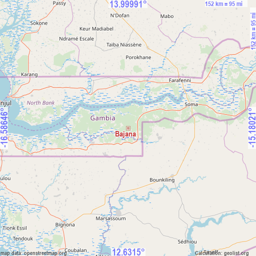
Bajana GPS coordinates[2]
13° 19' 0.012" North, 15° 52' 59.988" West
| Map corner | latitude | longitude |
|---|---|---|
| Upper-left | 13.99991°, | -16.58646° |
| Center: | 13.31667°, | -15.88333° |
| Lower-right: | 12.6315°, | -15.18021° |
| Map W x H: | 152.2×152.2 km | = 94.6×94.6mi |
| max Lat: | 13.8° ⇑87% North |
| Bajana: | 13.31667° |
| min Lat: | ⇓13% South 13.20194° |
| min Long | Bajana | max Long |
| -16.73389° | -15.88333° | -13.85° |
| W 21.1%⇐ | ⇒78.9% E |
Elevation
Elevation of Bajana is 33 m = 108 ft, and this is 11.9 m = 39 ft above average elevation for this country.
| Max E: |
49 m = 161 ft | 16.3% |
| Bajana | 33 m 108 ft | |
| Avg. | 21.1 m = 69 ft | |
Min E: |
1 m = 3 ft | 83.7% |
See also: Gambia elevation on elevation.city.
Geographical zone
Bajana is located in North Torrid zone (between Equator and Tropic of Cancer). Distance of this Northern Tropic circle is 1125.2 km =699.2 mi to North.| Distance of | km | miles | from Bajana |
|---|---|---|---|
| North Pole | 8526.4 | 5298.1 | to North |
| Arctic Circle | 5920.5 | 3678.8 | to North |
| Tropic Cancer | 1125.2 | 699.2 | to North |
| Equator | 1480.7 | 920.1 | to South |


Nearby cities:
15 places around Bajana: (largest is in red/bold)
• Dumbutu
6.6 km =4.1 mi,  55°
55°
• Jali
9.7 km =6 mi,  292°
292°
• Jarrol
9 km =5.6 mi,  153°
153°
• Jifarong
2.6 km =1.6 mi,  135°
135°
• Jiroff
22.7 km =14.1 mi, 60°
• Keneba
14.3 km =8.9 mi,  275°
275°
• Kuli Kunda
4.1 km =2.5 mi,  297°
297°
• Mayork
12.9 km =8 mi,  224°
224°
• Nema Kunku
7.4 km =4.6 mi,  180°
180°
• Nioro
14.9 km =9.3 mi,  75°
75°
• Sankandi
5.7 km =3.5 mi,  108°
108°
• Sibito
17.8 km =11.1 mi,  65°
65°
• Sintet
11.7 km =7.3 mi, 142°
• Tankular
20.1 km =12.5 mi, 304°
• Wurokang
10.3 km =6.4 mi,  44°
44°
Sources, notices
• [Note1] Compared only with cities in Gambia existing in our database
• [Src1] Map data: © OpenStreetMap contributors (CC-BY-SA)
• [Src2] Other city data from geonames.org with taken over terms of usage.
• [Src3] Geographical zone / Annual Mean Temperature by Robert A. Rohde @ Wikipedia
