Nioro geodata
Nioro (Lower River) is a populated place; located in Gambia in Africa/Banjul (GMT+0) time zone. With population of 1,746 people, there are 40 cities with bigger population in this country. Compared to other cities in Gambia, 81.3% of cities are located further ↑North; 71.5% of cities are located further →East and 88.6% of cities have lower elevation than Nioro. Note1


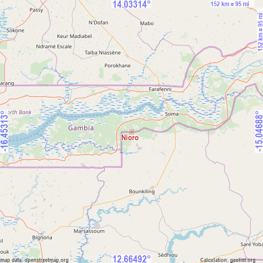
Nioro GPS coordinates[2]
13° 21' 0" North, 15° 45' 0" West
| Map corner | latitude | longitude |
|---|---|---|
| Upper-left | 14.03314°, | -16.45313° |
| Center: | 13.35°, | -15.75° |
| Lower-right: | 12.66492°, | -15.04688° |
| Map W x H: | 152.1×152.1 km | = 94.5×94.5mi |
| max Lat: | 13.8° ⇑81.3% North |
| Nioro: | 13.35° |
| min Lat: | ⇓18.7% South 13.20194° |
| min Long | Nioro | max Long |
| -16.73389° | -15.75° | -13.85° |
| W 28.5%⇐ | ⇒71.5% E |
Elevation
Elevation of Nioro is 38 m = 125 ft, and this is 16.9 m = 55 ft above average elevation for this country.
| Max E: |
49 m = 161 ft | 11.4% |
| Nioro | 38 m 125 ft | |
| Avg. | 21.1 m = 69 ft | |
Min E: |
1 m = 3 ft | 88.6% |
See also: Gambia elevation on elevation.city.
Geographical zone
Nioro is located in North Torrid zone (between Equator and Tropic of Cancer). Distance of this Northern Tropic circle is 1121.5 km =696.9 mi to North.| Distance of | km | miles | from Nioro |
|---|---|---|---|
| North Pole | 8522.7 | 5295.8 | to North |
| Arctic Circle | 5916.8 | 3676.5 | to North |
| Tropic Cancer | 1121.5 | 696.9 | to North |
| Equator | 1484.4 | 922.4 | to South |


Nearby cities:
15 places around Nioro: (largest is in red/bold)
• Bajana
14.9 km =9.3 mi,  255°
255°
• Dumbutu
9 km =5.6 mi,  270°
270°
• Jarrol
15.7 km =9.8 mi,  221°
221°
• Jifarong
13.8 km =8.6 mi,  246°
246°
• Jiffin
19.5 km =12.1 mi,  67°
67°
• Jiroff
9.2 km =5.7 mi,  36°
36°
• Kaiaf
15.5 km =9.6 mi, 68°
• Katchang
16.7 km =10.4 mi,  0°
0°
• Kuli Kunda
18.1 km =11.2 mi, 264°
• Massembe
14.6 km =9.1 mi,  59°
59°
• Nema Kunku
18.2 km =11.3 mi,  232°
232°
• Sankandi
10.6 km =6.6 mi,  238°
238°
• Sibito
4.1 km =2.5 mi,  25°
25°
• Sintet
14.8 km =9.2 mi,  209°
209°
• Wurokang
8.1 km =5 mi,  297°
297°
Sources, notices
• [Note1] Compared only with cities in Gambia existing in our database
• [Src1] Map data: © OpenStreetMap contributors (CC-BY-SA)
• [Src2] Other city data from geonames.org with taken over terms of usage.
• [Src3] Geographical zone / Annual Mean Temperature by Robert A. Rohde @ Wikipedia
