Katchang geodata
Katchang (North Bank) is a populated place; located in Gambia in Africa/Banjul (GMT+0) time zone. With population of 1,741 people, there are 41 cities with bigger population in this country. Compared to other cities in Gambia, 62.6% of cities are located further ↓South; 71.5% of cities are located further →East and 51.2% of cities have lower elevation than Katchang. Note1


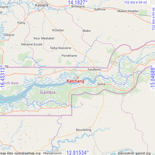
Katchang GPS coordinates[2]
13° 30' 0" North, 15° 45' 0" West
| Map corner | latitude | longitude |
|---|---|---|
| Upper-left | 14.1827°, | -16.45313° |
| Center: | 13.5°, | -15.75° |
| Lower-right: | 12.81534°, | -15.04688° |
| Map W x H: | 152×152 km | = 94.4×94.4mi |
| max Lat: | 13.8° ⇑37.4% North |
| Katchang: | 13.5° |
| min Lat: | ⇓62.6% South 13.20194° |
| min Long | Katchang | max Long |
| -16.73389° | -15.75° | -13.85° |
| W 28.5%⇐ | ⇒71.5% E |
Elevation
Elevation of Katchang is 20 m = 66 ft, and this is 1.1 m = 4 ft below average elevation for this country.
| Max E: |
49 m = 161 ft | 48.8% |
| Avg. | 21.1 m = 69 ft | |
| Katchang | 20 m = 66 ft | |
Min E: |
1 m = 3 ft | 51.2% |
See also: Gambia elevation on elevation.city.
Geographical zone
Katchang is located in North Torrid zone (between Equator and Tropic of Cancer). Distance of this Northern Tropic circle is 1104.9 km =686.6 mi to North.| Distance of | km | miles | from Katchang |
|---|---|---|---|
| North Pole | 8506 | 5285.4 | to North |
| Arctic Circle | 5900.1 | 3666.2 | to North |
| Tropic Cancer | 1104.9 | 686.6 | to North |
| Equator | 1501.1 | 932.7 | to South |


Nearby cities:
15 places around Katchang: (largest is in red/bold)
• Bantang Killing
10.7 km =6.6 mi,  30°
30°
• Dumbutu
19 km =11.8 mi,  208°
208°
• Farafenni
17.8 km =11.1 mi,  65°
65°
• India
7.4 km =4.6 mi,  0°
0°
• Jenoi
19.9 km =12.4 mi,  95°
95°
• Jeriko
12.9 km =8 mi,  44°
44°
• Jiroff
10.7 km =6.6 mi,  149°
149°
• Kaiaf
18.2 km =11.3 mi,  127°
127°
• Massembe
15.7 km =9.8 mi, 126°
• Nioro
16.7 km =10.4 mi,  180°
180°
• No Kunda
11.7 km =7.3 mi,  309°
309°
• Sibito
13.1 km =8.1 mi,  172°
172°
• Toniataba
19.5 km =12.1 mi,  112°
112°
• Wurokang
14.8 km =9.2 mi, 209°
• Yallal
7.8 km =4.8 mi, 44°
Sources, notices
• [Note1] Compared only with cities in Gambia existing in our database
• [Src1] Map data: © OpenStreetMap contributors (CC-BY-SA)
• [Src2] Other city data from geonames.org with taken over terms of usage.
• [Src3] Geographical zone / Annual Mean Temperature by Robert A. Rohde @ Wikipedia
