Kaiaf geodata
Kaiaf (Lower River) is a populated place; located in Gambia in Africa/Banjul (GMT+0) time zone. With population of 1,819 people, there are 34 cities with bigger population in this country. Compared to other cities in Gambia, 67.5% of cities are located further ↑North; 64.2% of cities are located further →East and 78% of cities have lower elevation than Kaiaf. Note1


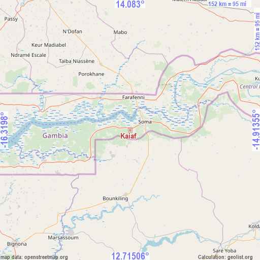
Kaiaf GPS coordinates[2]
13° 24' 0" North, 15° 37' 0.012" West
| Map corner | latitude | longitude |
|---|---|---|
| Upper-left | 14.083°, | -16.3198° |
| Center: | 13.4°, | -15.61667° |
| Lower-right: | 12.71506°, | -14.91355° |
| Map W x H: | 152.1×152.1 km | = 94.5×94.5mi |
| max Lat: | 13.8° ⇑67.5% North |
| Kaiaf: | 13.4° |
| min Lat: | ⇓32.5% South 13.20194° |
| min Long | Kaiaf | max Long |
| -16.73389° | -15.61667° | -13.85° |
| W 35.8%⇐ | ⇒64.2% E |
Elevation
Elevation of Kaiaf is 29 m = 95 ft, and this is 7.9 m = 26 ft above average elevation for this country.
| Max E: |
49 m = 161 ft | 22% |
| Kaiaf | 29 m 95 ft | |
| Avg. | 21.1 m = 69 ft | |
Min E: |
1 m = 3 ft | 78% |
See also: Gambia elevation on elevation.city.
Geographical zone
Kaiaf is located in North Torrid zone (between Equator and Tropic of Cancer). Distance of this Northern Tropic circle is 1116 km =693.5 mi to North.| Distance of | km | miles | from Kaiaf |
|---|---|---|---|
| North Pole | 8517.1 | 5292.3 | to North |
| Arctic Circle | 5911.2 | 3673 | to North |
| Tropic Cancer | 1116 | 693.5 | to North |
| Equator | 1489.9 | 925.8 | to South |


Nearby cities:
15 places around Kaiaf: (largest is in red/bold)
• Buiba Mandinka
18.4 km =11.4 mi,  78°
78°
• Farafenni
18.6 km =11.6 mi,  5°
5°
• Jenoi
10.7 km =6.6 mi,  30°
30°
• Jiffin
4.1 km =2.5 mi,  62°
62°
• Jiroff
9.2 km =5.7 mi,  281°
281°
• Karantaba
11.4 km =7.1 mi,  71°
71°
• Katchang
18.2 km =11.3 mi,  307°
307°
• Mansa Konko
10 km =6.2 mi, 61°
• Massembe
2.6 km =1.6 mi,  315°
315°
• Nioro
15.5 km =9.6 mi,  248°
248°
• Sankwia
13.1 km =8.1 mi, 55°
• Si Kunda
6.6 km =4.1 mi, 55°
• Sibito
12.8 km =8 mi,  261°
261°
• Soma
9.7 km =6 mi, 67°
• Toniataba
5.2 km =3.2 mi,  44°
44°
Sources, notices
• [Note1] Compared only with cities in Gambia existing in our database
• [Src1] Map data: © OpenStreetMap contributors (CC-BY-SA)
• [Src2] Other city data from geonames.org with taken over terms of usage.
• [Src3] Geographical zone / Annual Mean Temperature by Robert A. Rohde @ Wikipedia
