Diganteh geodata
Diganteh (Lower River) is a populated place; located in Gambia in Africa/Banjul (GMT+0) time zone. With population of 701 people, there are 95 cities with bigger population in this country. Compared to other cities in Gambia, 78% of cities are located further ↑North; 55.3% of cities are located further →East and 95.9% of cities have lower elevation than Diganteh. Note1


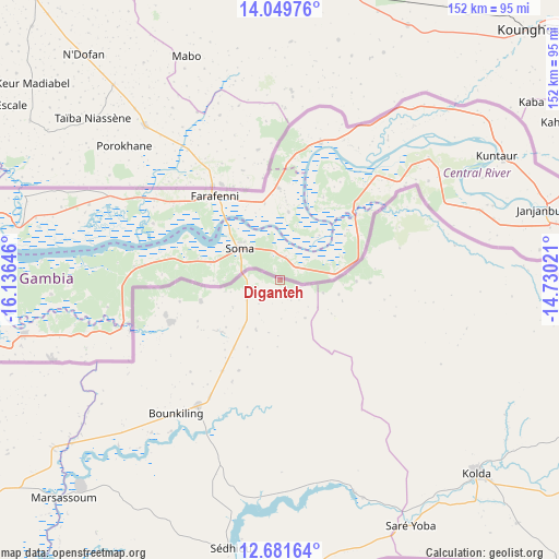
Diganteh GPS coordinates[2]
13° 22' 0.012" North, 15° 25' 59.988" West
| Map corner | latitude | longitude |
|---|---|---|
| Upper-left | 14.04976°, | -16.13646° |
| Center: | 13.36667°, | -15.43333° |
| Lower-right: | 12.68164°, | -14.73021° |
| Map W x H: | 152.1×152.1 km | = 94.5×94.5mi |
| max Lat: | 13.8° ⇑78% North |
| Diganteh: | 13.36667° |
| min Lat: | ⇓22% South 13.20194° |
| min Long | Diganteh | max Long |
| -16.73389° | -15.43333° | -13.85° |
| W 44.7%⇐ | ⇒55.3% E |
Elevation
Elevation of Diganteh is 46 m = 151 ft, and this is 24.9 m = 82 ft above average elevation for this country.
| Max E: |
49 m = 161 ft | 4.1% |
| Diganteh | 46 m 151 ft | |
| Avg. | 21.1 m = 69 ft | |
Min E: |
1 m = 3 ft | 95.9% |
See also: Gambia elevation on elevation.city.
Geographical zone
Diganteh is located in North Torrid zone (between Equator and Tropic of Cancer). Distance of this Northern Tropic circle is 1119.7 km =695.7 mi to North.| Distance of | km | miles | from Diganteh |
|---|---|---|---|
| North Pole | 8520.8 | 5294.6 | to North |
| Arctic Circle | 5914.9 | 3675.3 | to North |
| Tropic Cancer | 1119.7 | 695.7 | to North |
| Equator | 1486.2 | 923.5 | to South |


Nearby cities:
15 places around Diganteh: (largest is in red/bold)
• Bambali
16.9 km =10.5 mi,  39°
39°
• Buiba Mandinka
7.6 km =4.7 mi,  346°
346°
• Bureng
17.2 km =10.7 mi,  71°
71°
• Dongoro Ba
16.3 km =10.1 mi,  83°
83°
• Jassong
13.2 km =8.2 mi, 73°
• Jiffin
17.2 km =10.7 mi,  288°
288°
• Karantaba
11.7 km =7.3 mi,  309°
309°
• Kumbijae
18.5 km =11.5 mi,  0°
0°
• Mansa Konko
14 km =8.7 mi, 307°
• Sankwia
14.3 km =8.9 mi,  320°
320°
• Sara Kunda
18.6 km =11.6 mi,  5°
5°
• Si Kunda
16.2 km =10.1 mi,  297°
297°
• Soma
13.1 km =8.1 mi, 304°
• Toniataba
17.8 km =11.1 mi, 294°
• Wellingara Ba
6.6 km =4.1 mi,  32°
32°
Sources, notices
• [Note1] Compared only with cities in Gambia existing in our database
• [Src1] Map data: © OpenStreetMap contributors (CC-BY-SA)
• [Src2] Other city data from geonames.org with taken over terms of usage.
• [Src3] Geographical zone / Annual Mean Temperature by Robert A. Rohde @ Wikipedia
