Sankwia geodata
Sankwia (Lower River) is a populated place; located in Gambia in Africa/Banjul (GMT+0) time zone. With population of 1,831 people, there are 33 cities with bigger population in this country. Compared to other cities in Gambia, 51.2% of cities are located further ↓South; 57.7% of cities are located further →East and 97.6% of cities have higher elevation than Sankwia. Note1


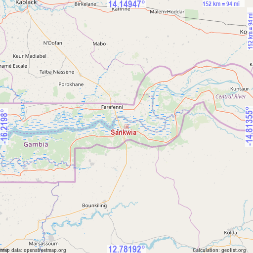
Sankwia GPS coordinates[2]
13° 28' 0.012" North, 15° 31' 0.012" West
| Map corner | latitude | longitude |
|---|---|---|
| Upper-left | 14.14947°, | -16.2198° |
| Center: | 13.46667°, | -15.51667° |
| Lower-right: | 12.78192°, | -14.81355° |
| Map W x H: | 152.1×152.1 km | = 94.5×94.5mi |
| max Lat: | 13.8° ⇑48.8% North |
| Sankwia: | 13.46667° |
| min Lat: | ⇓51.2% South 13.20194° |
| min Long | Sankwia | max Long |
| -16.73389° | -15.51667° | -13.85° |
| W 42.3%⇐ | ⇒57.7% E |
Elevation
Elevation of Sankwia is 4 m = 13 ft, and this is 17.1 m = 56 ft below average elevation for this country.
| Max E: |
49 m = 161 ft | 97.6% |
| Avg. | 21.1 m = 69 ft | |
| Sankwia | 4 m = 13 ft | |
Min E: |
1 m = 3 ft | 2.4% |
See also: Gambia elevation on elevation.city.
Geographical zone
Sankwia is located in North Torrid zone (between Equator and Tropic of Cancer). Distance of this Northern Tropic circle is 1108.6 km =688.9 mi to North.| Distance of | km | miles | from Sankwia |
|---|---|---|---|
| North Pole | 8509.7 | 5287.7 | to North |
| Arctic Circle | 5903.8 | 3668.5 | to North |
| Tropic Cancer | 1108.6 | 688.9 | to North |
| Equator | 1497.4 | 930.4 | to South |


Nearby cities:
15 places around Sankwia: (largest is in red/bold)
• Buiba Mandinka
8.1 km =5 mi,  117°
117°
• Diganteh
14.3 km =8.9 mi,  140°
140°
• Farafenni
14.3 km =8.9 mi,  320°
320°
• Jenoi
5.7 km =3.5 mi,  288°
288°
• Jiffin
9.1 km =5.7 mi,  232°
232°
• Kaiaf
13.1 km =8.1 mi,  235°
235°
• Karantaba
3.7 km =2.3 mi,  180°
180°
• Kumbijae
11.7 km =7.3 mi,  50°
50°
• Mansa Konko
3.3 km =2.1 mi,  218°
218°
• Massembe
13.8 km =8.6 mi,  246°
246°
• Sara Kunda
13.1 km =8.1 mi,  55°
55°
• Si Kunda
6.6 km =4.1 mi, 235°
• Soma
4.1 km =2.5 mi,  205°
205°
• Toniataba
8.1 km =5 mi, 242°
• Wellingara Ba
13.8 km =8.6 mi,  113°
113°
Sources, notices
• [Note1] Compared only with cities in Gambia existing in our database
• [Src1] Map data: © OpenStreetMap contributors (CC-BY-SA)
• [Src2] Other city data from geonames.org with taken over terms of usage.
• [Src3] Geographical zone / Annual Mean Temperature by Robert A. Rohde @ Wikipedia
