Jiffin geodata
Jiffin (Lower River) is a populated place; located in Gambia in Africa/Banjul (GMT+0) time zone. With population of 729 people, there are 92 cities with bigger population in this country. Compared to other cities in Gambia, 64.2% of cities are located further ↑North; 62.6% of cities are located further →East and 83.7% of cities have lower elevation than Jiffin. Note1


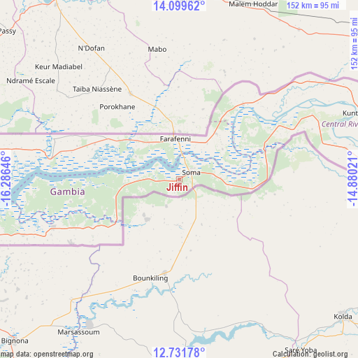
Jiffin GPS coordinates[2]
13° 25' 0.012" North, 15° 34' 59.988" West
| Map corner | latitude | longitude |
|---|---|---|
| Upper-left | 14.09962°, | -16.28646° |
| Center: | 13.41667°, | -15.58333° |
| Lower-right: | 12.73178°, | -14.88021° |
| Map W x H: | 152.1×152.1 km | = 94.5×94.5mi |
| max Lat: | 13.8° ⇑64.2% North |
| Jiffin: | 13.41667° |
| min Lat: | ⇓35.8% South 13.20194° |
| min Long | Jiffin | max Long |
| -16.73389° | -15.58333° | -13.85° |
| W 37.4%⇐ | ⇒62.6% E |
Elevation
Elevation of Jiffin is 33 m = 108 ft, and this is 11.9 m = 39 ft above average elevation for this country.
| Max E: |
49 m = 161 ft | 16.3% |
| Jiffin | 33 m 108 ft | |
| Avg. | 21.1 m = 69 ft | |
Min E: |
1 m = 3 ft | 83.7% |
See also: Gambia elevation on elevation.city.
Geographical zone
Jiffin is located in North Torrid zone (between Equator and Tropic of Cancer). Distance of this Northern Tropic circle is 1114.1 km =692.3 mi to North.| Distance of | km | miles | from Jiffin |
|---|---|---|---|
| North Pole | 8515.3 | 5291.2 | to North |
| Arctic Circle | 5909.4 | 3671.9 | to North |
| Tropic Cancer | 1114.1 | 692.3 | to North |
| Equator | 1491.8 | 927 | to South |


Nearby cities:
15 places around Jiffin: (largest is in red/bold)
• Buiba Mandinka
14.5 km =9 mi,  82°
82°
• Diganteh
17.2 km =10.7 mi,  108°
108°
• Farafenni
16.8 km =10.4 mi,  353°
353°
• Jenoi
7.6 km =4.7 mi,  13°
13°
• Jiroff
12.6 km =7.8 mi,  270°
270°
• Kaiaf
4.1 km =2.5 mi,  242°
242°
• Karantaba
7.4 km =4.6 mi, 75°
• Mansa Konko
5.9 km =3.7 mi,  60°
60°
• Massembe
5.4 km =3.4 mi, 270°
• Nioro
19.5 km =12.1 mi,  247°
247°
• Sankwia
9.1 km =5.7 mi,  52°
52°
• Si Kunda
2.6 km =1.6 mi,  44°
44°
• Sibito
16.6 km =10.3 mi,  257°
257°
• Soma
5.7 km =3.5 mi,  71°
71°
• Toniataba
1.9 km =1.2 mi,  0°
0°
Sources, notices
• [Note1] Compared only with cities in Gambia existing in our database
• [Src1] Map data: © OpenStreetMap contributors (CC-BY-SA)
• [Src2] Other city data from geonames.org with taken over terms of usage.
• [Src3] Geographical zone / Annual Mean Temperature by Robert A. Rohde @ Wikipedia
