Othonoí geodata
Othonoí (Ionian Islands) is a populated place; located in Greece in Europe/Athens (GMT+3) time zone. With population of 761 people, there are 1316 cities with bigger population in this country. Compared to other cities in Greece, 65% of cities are located further ↓South; 100% of cities are located further →East and 89.2% of cities have higher elevation than Othonoí. Note1


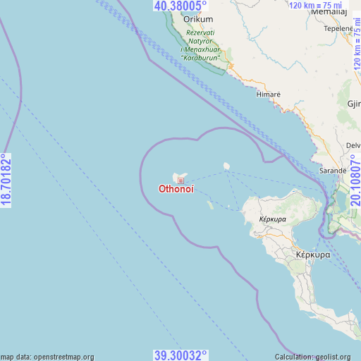
Othonoí GPS coordinates[2]
39° 50' 32.316" North, 19° 24' 17.784" East
| Map corner | latitude | longitude |
|---|---|---|
| Upper-left | 40.38005°, | 18.70182° |
| Center: | 39.84231°, | 19.40494° |
| Lower-right: | 39.30032°, | 20.10807° |
| Map W x H: | 120.1×120.1 km | = 74.6×74.6mi |
| max Lat: | 41.72048° ⇑35% North |
| Othonoí: | 39.84231° |
| min Lat: | ⇓65% South 34.8346° |
| min Long | Othonoí | max Long |
| 19.40494° | 19.40494° | 29.59361° |
| W 0%⇐ | ⇒100% E |
Elevation
Elevation of Othonoí is 9 m = 30 ft, and this is 159.9 m = 525 ft below average elevation for this country.
| Max E: |
1439 m = 4721 ft | 89.2% |
| Avg. | 168.9 m = 554 ft | |
| Othonoí | 9 m = 30 ft | |
Min E: |
0 m = 0 ft | 10.8% |
See also: Greece elevation on elevation.city.
Geographical zone
Othonoí is located in North temperate zone (between Tropic of Cancer and the Arctic Circle). Distance of this Northern Tropic circle is 1824.1 km =1133.4 mi to South.| Distance of | km | miles | from Othonoí |
|---|---|---|---|
| North Pole | 5577 | 3465.4 | to North |
| Arctic Circle | 2971.1 | 1846.2 | to North |
| Tropic Cancer | 1824.1 | 1133.4 | to South |
| Equator | 4430 | 2752.7 | to South |


Nearby cities:
15 places around Othonoí: (largest is in red/bold)
• Acharávi
35.6 km =22.1 mi,  98°
98°
• Agios Georgis
28.4 km =17.6 mi,  117°
117°
• Avliótes
23.2 km =14.4 mi,  108°
108°
• Doukádes
33.3 km =20.7 mi, 120°
• Giannádes
38.6 km =24 mi,  127°
127°
• Karousádes
29.8 km =18.5 mi, 103°
• Kavvadádes
25.8 km =16 mi, 114°
• Káto Agios Márkos
39.6 km =24.6 mi, 112°
• Káto Korakiána
39.9 km =24.8 mi, 115°
• Liapádes
34.5 km =21.4 mi, 123°
• Nýmfes
33.9 km =21.1 mi, 106°
• Perouládes
23.7 km =14.7 mi, 105°
• Róda
33.7 km =20.9 mi, 100°
• Spartýlas
39.7 km =24.7 mi, 109°
• Áno Korakiána
36.4 km =22.6 mi, 114°
Sources, notices
• [Note1] Compared only with cities in Greece existing in our database
• [Src1] Map data: © OpenStreetMap contributors (CC-BY-SA)
• [Src2] Other city data from geonames.org with taken over terms of usage.
• [Src3] Geographical zone / Annual Mean Temperature by Robert A. Rohde @ Wikipedia
