Moraḯtika geodata
Moraḯtika (Ionian Islands) is a populated place; located in Greece in Europe/Athens (GMT+3) time zone. With population of 553 people, there are 1695 cities with bigger population in this country. Compared to other cities in Greece, 56% of cities are located further ↓South; 97.8% of cities are located further →East and 85.7% of cities have higher elevation than Moraḯtika. Note1


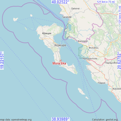
Moraḯtika GPS coordinates[2]
39° 29' 4.812" North, 19° 55' 28.884" East
| Map corner | latitude | longitude |
|---|---|---|
| Upper-left | 40.02522°, | 19.22157° |
| Center: | 39.48467°, | 19.92469° |
| Lower-right: | 38.93989°, | 20.62782° |
| Map W x H: | 120.7×120.7 km | = 75×75mi |
| max Lat: | 41.72048° ⇑44% North |
| Moraḯtika: | 39.48467° |
| min Lat: | ⇓56% South 34.8346° |
| min Long | Moraḯtika | max Long |
| 19.40494° | 19.92469° | 29.59361° |
| W 2.2%⇐ | ⇒97.8% E |
Elevation
Elevation of Moraḯtika is 12 m = 39 ft, and this is 156.9 m = 515 ft below average elevation for this country.
| Max E: |
1439 m = 4721 ft | 85.7% |
| Avg. | 168.9 m = 554 ft | |
| Moraḯtika | 12 m = 39 ft | |
Min E: |
0 m = 0 ft | 14.3% |
See also: Greece elevation on elevation.city.
Geographical zone
Moraḯtika is located in North temperate zone (between Tropic of Cancer and the Arctic Circle). Distance of this Northern Tropic circle is 1784.4 km =1108.8 mi to South.| Distance of | km | miles | from Moraḯtika |
|---|---|---|---|
| North Pole | 5616.8 | 3490.1 | to North |
| Arctic Circle | 3010.9 | 1870.9 | to North |
| Tropic Cancer | 1784.4 | 1108.8 | to South |
| Equator | 4390.3 | 2728 | to South |


Nearby cities:
15 places around Moraḯtika: (largest is in red/bold)
• Agios Geórgios Argyrádon
6.7 km =4.2 mi,  162°
162°
• Argyrádes
7.1 km =4.4 mi,  141°
141°
• Benítses
6.6 km =4.1 mi,  351°
351°
• Chrysiída
12 km =7.5 mi, 348°
• Gastoúri
8.8 km =5.5 mi, 345°
• Kanáli
13.7 km =8.5 mi, 348°
• Kastanéa
12.5 km =7.8 mi,  344°
344°
• Kynopiástes
9.9 km =6.2 mi, 339°
• Káto Garoúna
7.9 km =4.9 mi,  319°
319°
• Perama
11 km =6.8 mi, 354°
• Perivóli
10.6 km =6.6 mi,  133°
133°
• Petrití
7.2 km =4.5 mi,  118°
118°
• Sinarádes
11.1 km =6.9 mi, 323°
• Virós
11.6 km =7.2 mi, 341°
• Ágios Matthaíos
4.6 km =2.9 mi,  284°
284°
Sources, notices
• [Note1] Compared only with cities in Greece existing in our database
• [Src1] Map data: © OpenStreetMap contributors (CC-BY-SA)
• [Src2] Other city data from geonames.org with taken over terms of usage.
• [Src3] Geographical zone / Annual Mean Temperature by Robert A. Rohde @ Wikipedia
