Perama geodata
Perama (Ionian Islands) is a populated place; located in Greece in Europe/Athens (GMT+3) time zone. With population of 1,021 people, there are 992 cities with bigger population in this country. Compared to other cities in Greece, 58.8% of cities are located further ↓South; 98.1% of cities are located further →East and 56.8% of cities have higher elevation than Perama. Note1


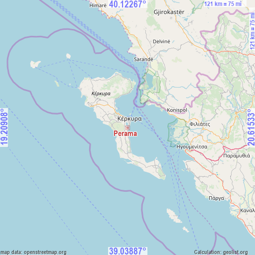
Perama GPS coordinates[2]
39° 34' 58.404" North, 19° 54' 43.92" East
| Map corner | latitude | longitude |
|---|---|---|
| Upper-left | 40.12267°, | 19.20908° |
| Center: | 39.58289°, | 19.9122° |
| Lower-right: | 39.03887°, | 20.61533° |
| Map W x H: | 120.5×120.5 km | = 74.9×74.9mi |
| max Lat: | 41.72048° ⇑41.2% North |
| Perama: | 39.58289° |
| min Lat: | ⇓58.8% South 34.8346° |
| min Long | Perama | max Long |
| 19.40494° | 19.9122° | 29.59361° |
| W 1.9%⇐ | ⇒98.1% E |
Elevation
Elevation of Perama is 60 m = 197 ft, and this is 108.9 m = 357 ft below average elevation for this country.
| Max E: |
1439 m = 4721 ft | 56.8% |
| Avg. | 168.9 m = 554 ft | |
| Perama | 60 m = 197 ft | |
Min E: |
0 m = 0 ft | 43.2% |
See also: Greece elevation on elevation.city.
Geographical zone
Perama is located in North temperate zone (between Tropic of Cancer and the Arctic Circle). Distance of this Northern Tropic circle is 1795.3 km =1115.5 mi to South.| Distance of | km | miles | from Perama |
|---|---|---|---|
| North Pole | 5605.9 | 3483.3 | to North |
| Arctic Circle | 3000 | 1864.1 | to North |
| Tropic Cancer | 1795.3 | 1115.5 | to South |
| Equator | 4401.2 | 2734.8 | to South |


Nearby cities:
15 places around Perama: (largest is in red/bold)
• Alepoú
3.9 km =2.4 mi,  338°
338°
• Benítses
4.4 km =2.7 mi,  178°
178°
• Chrysiída
1.5 km =0.9 mi,  302°
302°
• Corfu
4.3 km =2.7 mi,  8°
8°
• Gastoúri
2.7 km =1.7 mi,  205°
205°
• Kanáli
3 km =1.9 mi,  326°
326°
• Kastanéa
2.6 km =1.6 mi,  294°
294°
• Kompítsion
4.6 km =2.9 mi, 302°
• Kynopiástes
3 km =1.9 mi,  235°
235°
• Káto Garoúna
6.3 km =3.9 mi,  219°
219°
• Potamós
5.4 km =3.4 mi, 327°
• Sinarádes
5.8 km =3.6 mi,  250°
250°
• Virós
2.5 km =1.6 mi,  271°
271°
• Áfra
6.3 km =3.9 mi,  313°
313°
• Ágios Ioánnis
6.6 km =4.1 mi, 303°
Sources, notices
• [Note1] Compared only with cities in Greece existing in our database
• [Src1] Map data: © OpenStreetMap contributors (CC-BY-SA)
• [Src2] Other city data from geonames.org with taken over terms of usage.
• [Src3] Geographical zone / Annual Mean Temperature by Robert A. Rohde @ Wikipedia
