Chrysiída geodata
Chrysiída (Ionian Islands) is a populated place; located in Greece in Europe/Athens (GMT+3) time zone. With population of 898 people, there are 1132 cities with bigger population in this country. Compared to other cities in Greece, 59.1% of cities are located further ↓South; 98.2% of cities are located further →East and 87.7% of cities have higher elevation than Chrysiída. Note1


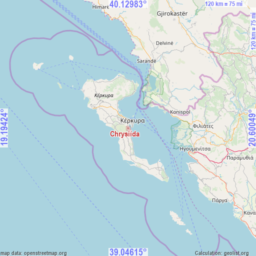
Chrysiída GPS coordinates[2]
39° 35' 24.396" North, 19° 53' 50.496" East
| Map corner | latitude | longitude |
|---|---|---|
| Upper-left | 40.12983°, | 19.19424° |
| Center: | 39.59011°, | 19.89736° |
| Lower-right: | 39.04615°, | 20.60049° |
| Map W x H: | 120.5×120.5 km | = 74.9×74.9mi |
| max Lat: | 41.72048° ⇑40.9% North |
| Chrysiída: | 39.59011° |
| min Lat: | ⇓59.1% South 34.8346° |
| min Long | Chrysiída | max Long |
| 19.40494° | 19.89736° | 29.59361° |
| W 1.8%⇐ | ⇒98.2% E |
Elevation
Elevation of Chrysiída is 10 m = 33 ft, and this is 158.9 m = 521 ft below average elevation for this country.
| Max E: |
1439 m = 4721 ft | 87.7% |
| Avg. | 168.9 m = 554 ft | |
| Chrysiída | 10 m = 33 ft | |
Min E: |
0 m = 0 ft | 12.3% |
See also: Greece elevation on elevation.city.
Geographical zone
Chrysiída is located in North temperate zone (between Tropic of Cancer and the Arctic Circle). Distance of this Northern Tropic circle is 1796.1 km =1116 mi to South.| Distance of | km | miles | from Chrysiída |
|---|---|---|---|
| North Pole | 5605.1 | 3482.8 | to North |
| Arctic Circle | 2999.2 | 1863.6 | to North |
| Tropic Cancer | 1796.1 | 1116 | to South |
| Equator | 4402 | 2735.3 | to South |


Nearby cities:
15 places around Chrysiída: (largest is in red/bold)
• Alepoú
2.9 km =1.8 mi,  357°
357°
• Benítses
5.3 km =3.3 mi,  164°
164°
• Corfu
3.9 km =2.4 mi,  29°
29°
• Gastoúri
3.2 km =2 mi,  178°
178°
• Kanáli
1.8 km =1.1 mi,  346°
346°
• Kastanéa
1.1 km =0.7 mi,  285°
285°
• Kompítsion
3.1 km =1.9 mi,  303°
303°
• Kynopiástes
2.7 km =1.7 mi,  205°
205°
• Káto Garoúna
6.3 km =3.9 mi, 206°
• Perama
1.5 km =0.9 mi,  122°
122°
• Potamós
4.1 km =2.5 mi,  336°
336°
• Sinarádes
5 km =3.1 mi,  237°
237°
• Virós
1.5 km =0.9 mi, 239°
• Áfra
4.8 km =3 mi,  316°
316°
• Ágios Ioánnis
5.1 km =3.2 mi, 303°
Sources, notices
• [Note1] Compared only with cities in Greece existing in our database
• [Src1] Map data: © OpenStreetMap contributors (CC-BY-SA)
• [Src2] Other city data from geonames.org with taken over terms of usage.
• [Src3] Geographical zone / Annual Mean Temperature by Robert A. Rohde @ Wikipedia
