Kassiópi geodata
Kassiópi (Ionian Islands) is a populated place; located in Greece in Europe/Athens (GMT+3) time zone. With population of 812 people, there are 1261 cities with bigger population in this country. Compared to other cities in Greece, 64.4% of cities are located further ↓South; 97.9% of cities are located further →East and 97.4% of cities have higher elevation than Kassiópi. Note1


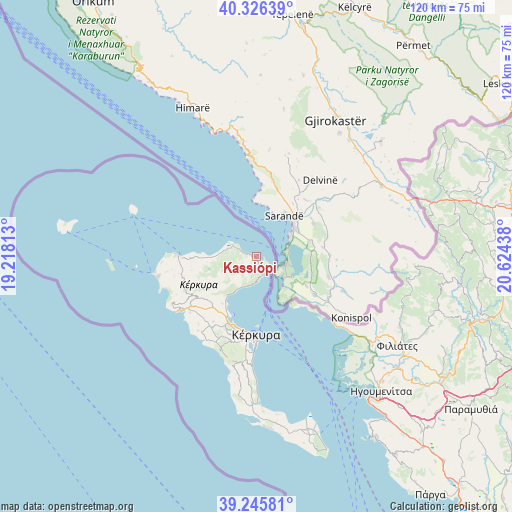
Kassiópi GPS coordinates[2]
39° 47' 17.592" North, 19° 55' 16.5" East
| Map corner | latitude | longitude |
|---|---|---|
| Upper-left | 40.32639°, | 19.21813° |
| Center: | 39.78822°, | 19.92125° |
| Lower-right: | 39.24581°, | 20.62438° |
| Map W x H: | 120.1×120.1 km | = 74.6×74.6mi |
| max Lat: | 41.72048° ⇑35.6% North |
| Kassiópi: | 39.78822° |
| min Lat: | ⇓64.4% South 34.8346° |
| min Long | Kassiópi | max Long |
| 19.40494° | 19.92125° | 29.59361° |
| W 2.1%⇐ | ⇒97.9% E |
Elevation
Elevation of Kassiópi is 4 m = 13 ft, and this is 164.9 m = 541 ft below average elevation for this country.
| Max E: |
1439 m = 4721 ft | 97.4% |
| Avg. | 168.9 m = 554 ft | |
| Kassiópi | 4 m = 13 ft | |
Min E: |
0 m = 0 ft | 2.6% |
See also: Greece elevation on elevation.city.
Geographical zone
Kassiópi is located in North temperate zone (between Tropic of Cancer and the Arctic Circle). Distance of this Northern Tropic circle is 1818.1 km =1129.7 mi to South.| Distance of | km | miles | from Kassiópi |
|---|---|---|---|
| North Pole | 5583 | 3469.1 | to North |
| Arctic Circle | 2977.1 | 1849.9 | to North |
| Tropic Cancer | 1818.1 | 1129.7 | to South |
| Equator | 4424 | 2748.9 | to South |


Nearby cities:
15 places around Kassiópi: (largest is in red/bold)
• Acharávi
8.9 km =5.5 mi,  273°
273°
• Corfu
18.6 km =11.6 mi,  180°
180°
• Gouviá
16.5 km =10.3 mi,  204°
204°
• Karousádes
15.1 km =9.4 mi, 266°
• Kontokáli
17.1 km =10.6 mi, 200°
• Kyrá Chrysikoú
18 km =11.2 mi, 204°
• Káto Agios Márkos
11.8 km =7.3 mi,  219°
219°
• Káto Korakiána
13.5 km =8.4 mi, 216°
• Límni
15.2 km =9.4 mi, 204°
• Nýmfes
12.2 km =7.6 mi,  252°
252°
• Potamós
18.6 km =11.6 mi,  191°
191°
• Róda
11 km =6.8 mi, 269°
• Spartýlas
10.1 km =6.3 mi, 222°
• Ypsos
12.7 km =7.9 mi,  214°
214°
• Áno Korakiána
14.3 km =8.9 mi,  230°
230°
Sources, notices
• [Note1] Compared only with cities in Greece existing in our database
• [Src1] Map data: © OpenStreetMap contributors (CC-BY-SA)
• [Src2] Other city data from geonames.org with taken over terms of usage.
• [Src3] Geographical zone / Annual Mean Temperature by Robert A. Rohde @ Wikipedia
