Potamós geodata
Potamós (Ionian Islands) is a populated place; located in Greece in Europe/Athens (GMT+3) time zone. With population of 3,840 people, there are 288 cities with bigger population in this country. Compared to other cities in Greece, 60.7% of cities are located further ↓South; 98.5% of cities are located further →East and 81.5% of cities have higher elevation than Potamós. Note1


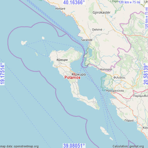
Potamós GPS coordinates[2]
39° 37' 27.12" North, 19° 52' 41.736" East
| Map corner | latitude | longitude |
|---|---|---|
| Upper-left | 40.16366°, | 19.17514° |
| Center: | 39.6242°, | 19.87826° |
| Lower-right: | 39.08051°, | 20.58139° |
| Map W x H: | 120.4×120.4 km | = 74.8×74.8mi |
| max Lat: | 41.72048° ⇑39.3% North |
| Potamós: | 39.6242° |
| min Lat: | ⇓60.7% South 34.8346° |
| min Long | Potamós | max Long |
| 19.40494° | 19.87826° | 29.59361° |
| W 1.5%⇐ | ⇒98.5% E |
Elevation
Elevation of Potamós is 16 m = 52 ft, and this is 152.9 m = 502 ft below average elevation for this country.
| Max E: |
1439 m = 4721 ft | 81.5% |
| Avg. | 168.9 m = 554 ft | |
| Potamós | 16 m = 52 ft | |
Min E: |
0 m = 0 ft | 18.5% |
See also: Greece elevation on elevation.city.
Geographical zone
Potamós is located in North temperate zone (between Tropic of Cancer and the Arctic Circle). Distance of this Northern Tropic circle is 1799.9 km =1118.4 mi to South.| Distance of | km | miles | from Potamós |
|---|---|---|---|
| North Pole | 5601.3 | 3480.5 | to North |
| Arctic Circle | 2995.4 | 1861.3 | to North |
| Tropic Cancer | 1799.9 | 1118.4 | to South |
| Equator | 4405.8 | 2737.6 | to South |


Nearby cities:
15 places around Potamós: (largest is in red/bold)
• Alepoú
1.7 km =1.1 mi,  121°
121°
• Chrysiída
4.1 km =2.5 mi,  156°
156°
• Corfu
3.6 km =2.2 mi,  96°
96°
• Gouviá
4.4 km =2.7 mi,  316°
316°
• Kanáli
2.4 km =1.5 mi,  149°
149°
• Kastanéa
3.5 km =2.2 mi,  171°
171°
• Kokkínion
5.7 km =3.5 mi,  252°
252°
• Kompítsion
2.3 km =1.4 mi,  204°
204°
• Kontokáli
3.2 km =2 mi,  314°
314°
• Kyrá Chrysikoú
4.1 km =2.5 mi,  295°
295°
• Límni
5.1 km =3.2 mi,  329°
329°
• Perama
5.4 km =3.4 mi, 147°
• Virós
4.6 km =2.9 mi,  175°
175°
• Áfra
1.7 km =1.1 mi,  260°
260°
• Ágios Ioánnis
2.8 km =1.7 mi, 250°
Sources, notices
• [Note1] Compared only with cities in Greece existing in our database
• [Src1] Map data: © OpenStreetMap contributors (CC-BY-SA)
• [Src2] Other city data from geonames.org with taken over terms of usage.
• [Src3] Geographical zone / Annual Mean Temperature by Robert A. Rohde @ Wikipedia
