Adelianós Kámpos geodata
Adelianós Kámpos (Crete) is a populated place; located in Greece in Europe/Athens (GMT+3) time zone. With population of 680 people, there are 1445 cities with bigger population in this country. Compared to other cities in Greece, 95.2% of cities are located further ↑North; 83.9% of cities are located further ←West and 92.5% of cities have higher elevation than Adelianós Kámpos. Note1


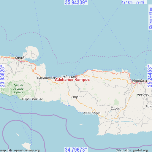
Adelianós Kámpos GPS coordinates[2]
35° 22' 19.56" North, 24° 32' 29.04" East
| Map corner | latitude | longitude |
|---|---|---|
| Upper-left | 35.94339°, | 23.83828° |
| Center: | 35.3721°, | 24.5414° |
| Lower-right: | 34.79673°, | 25.24453° |
| Map W x H: | 127.5×127.5 km | = 79.2×79.2mi |
| max Lat: | 41.72048° ⇑95.2% North |
| Adelianós Kámpos: | 35.3721° |
| min Lat: | ⇓4.8% South 34.8346° |
| min Long | Adelianós Kám | max Long |
| 19.40494° | 24.5414° | 29.59361° |
| W 83.9%⇐ | ⇒16.1% E |
Elevation
Elevation of Adelianós Kámpos is 7 m = 23 ft, and this is 161.9 m = 531 ft below average elevation for this country.
| Max E: |
1439 m = 4721 ft | 92.5% |
| Avg. | 168.9 m = 554 ft | |
| Adelianós Kámpos | 7 m = 23 ft | |
Min E: |
0 m = 0 ft | 7.5% |
See also: Greece elevation on elevation.city.
Geographical zone
Adelianós Kámpos is located in North temperate zone (between Tropic of Cancer and the Arctic Circle). Distance of this Northern Tropic circle is 1327.1 km =824.6 mi to South.| Distance of | km | miles | from Adelianós Kámpos |
|---|---|---|---|
| North Pole | 6074.1 | 3774.3 | to North |
| Arctic Circle | 3468.2 | 2155 | to North |
| Tropic Cancer | 1327.1 | 824.6 | to South |
| Equator | 3933 | 2443.9 | to South |


Nearby cities:
15 places around Adelianós Kámpos: (largest is in red/bold)
• Agía Foteiní
15.6 km =9.7 mi,  146°
146°
• Atsipópoulo
10 km =6.2 mi,  257°
257°
• Episkopí
19.3 km =12 mi, 255°
• Georgioupolis
25.5 km =15.8 mi,  267°
267°
• Geráni
13 km =8.1 mi, 260°
• Gállos
8.6 km =5.3 mi,  250°
250°
• Prinés
10.9 km =6.8 mi, 254°
• Pánormos
14.5 km =9 mi,  69°
69°
• Pérama
14.7 km =9.1 mi,  90°
90°
• Rethymno
5.4 km =3.4 mi, 262°
• Roussospíti
6 km =3.7 mi,  224°
224°
• Sfakáki
3.9 km =2.4 mi, 74°
• Spílion
17 km =10.6 mi,  182°
182°
• Stavroménos Rethýmnis
4.6 km =2.9 mi, 74°
• Violí Charáki
9.4 km =5.8 mi, 260°
Sources, notices
• [Note1] Compared only with cities in Greece existing in our database
• [Src1] Map data: © OpenStreetMap contributors (CC-BY-SA)
• [Src2] Other city data from geonames.org with taken over terms of usage.
• [Src3] Geographical zone / Annual Mean Temperature by Robert A. Rohde @ Wikipedia
