Prinés geodata
Prinés (Crete) is a populated place; located in Greece in Europe/Athens (GMT+3) time zone. With population of 851 people, there are 1196 cities with bigger population in this country. Compared to other cities in Greece, 95.7% of cities are located further ↑North; 82.9% of cities are located further ←West and 74.2% of cities have lower elevation than Prinés. Note1


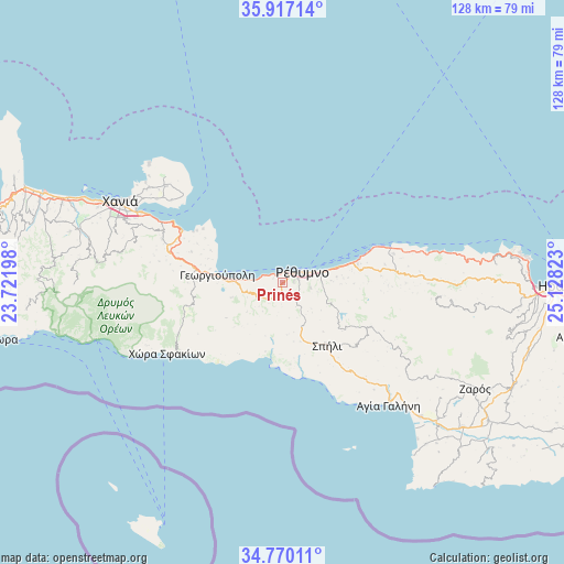
Prinés GPS coordinates[2]
35° 20' 44.376" North, 24° 25' 30.36" East
| Map corner | latitude | longitude |
|---|---|---|
| Upper-left | 35.91714°, | 23.72198° |
| Center: | 35.34566°, | 24.4251° |
| Lower-right: | 34.77011°, | 25.12823° |
| Map W x H: | 127.5×127.5 km | = 79.2×79.2mi |
| max Lat: | 41.72048° ⇑95.7% North |
| Prinés: | 35.34566° |
| min Lat: | ⇓4.3% South 34.8346° |
| min Long | Prinés | max Long |
| 19.40494° | 24.4251° | 29.59361° |
| W 82.9%⇐ | ⇒17.1% E |
Elevation
Elevation of Prinés is 202 m = 663 ft, and this is 33.1 m = 109 ft above average elevation for this country.
| Max E: |
1439 m = 4721 ft | 25.8% |
| Prinés | 202 m 663 ft | |
| Avg. | 168.9 m = 554 ft | |
Min E: |
0 m = 0 ft | 74.2% |
See also: Greece elevation on elevation.city.
Geographical zone
Prinés is located in North temperate zone (between Tropic of Cancer and the Arctic Circle). Distance of this Northern Tropic circle is 1324.2 km =822.8 mi to South.| Distance of | km | miles | from Prinés |
|---|---|---|---|
| North Pole | 6077 | 3776.1 | to North |
| Arctic Circle | 3471.1 | 2156.8 | to North |
| Tropic Cancer | 1324.2 | 822.8 | to South |
| Equator | 3930.1 | 2442.1 | to South |


Nearby cities:
15 places around Prinés: (largest is in red/bold)
• Adelianós Kámpos
10.9 km =6.8 mi,  74°
74°
• Agía Foteiní
21.6 km =13.4 mi,  118°
118°
• Atsipópoulo
1.1 km =0.7 mi,  45°
45°
• Episkopí
8.4 km =5.2 mi,  256°
256°
• Georgioupolis
15.1 km =9.4 mi,  277°
277°
• Geráni
2.4 km =1.5 mi,  291°
291°
• Gállos
2.4 km =1.5 mi,  86°
86°
• Rethymno
5.6 km =3.5 mi, 66°
• Roussospíti
6.4 km =4 mi,  101°
101°
• Sfakáki
14.8 km =9.2 mi, 74°
• Spílion
17.2 km =10.7 mi,  144°
144°
• Stavroménos Rethýmnis
15.6 km =9.7 mi, 74°
• Violí Charáki
1.9 km =1.2 mi,  40°
40°
• Vrýses
20.6 km =12.8 mi, 279°
• Vámos
21.5 km =13.4 mi, 288°
Sources, notices
• [Note1] Compared only with cities in Greece existing in our database
• [Src1] Map data: © OpenStreetMap contributors (CC-BY-SA)
• [Src2] Other city data from geonames.org with taken over terms of usage.
• [Src3] Geographical zone / Annual Mean Temperature by Robert A. Rohde @ Wikipedia
