Agía Foteiní geodata
Agía Foteiní (Crete) is a seat of a third-order administrative division; located in Greece in Europe/Athens (GMT+3) time zone. In our database, there are 1823 cities with bigger population. Compared to other cities in Greece, 97.4% of cities are located further ↑North; 84.4% of cities are located further ←West and 88.6% of cities have lower elevation than Agía Foteiní. Note1


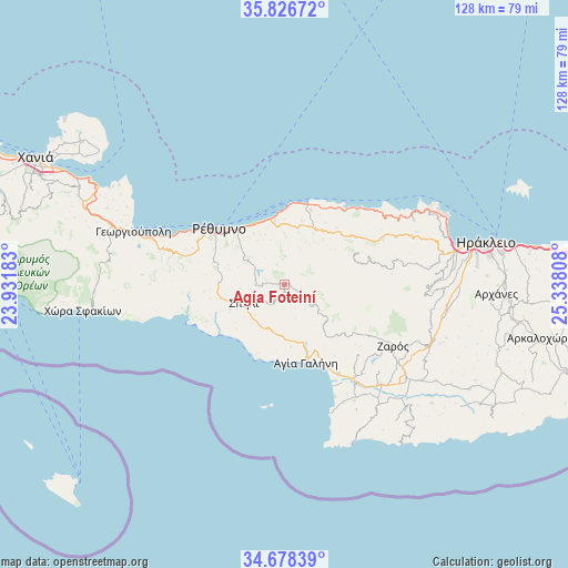
Agía Foteiní GPS coordinates[2]
35° 15' 16.524" North, 24° 38' 5.82" East
| Map corner | latitude | longitude |
|---|---|---|
| Upper-left | 35.82672°, | 23.93183° |
| Center: | 35.25459°, | 24.63495° |
| Lower-right: | 34.67839°, | 25.33808° |
| Map W x H: | 127.7×127.7 km | = 79.3×79.3mi |
| max Lat: | 41.72048° ⇑97.4% North |
| Agía Foteiní: | 35.25459° |
| min Lat: | ⇓2.6% South 34.8346° |
| min Long | Agía Foteiní | max Long |
| 19.40494° | 24.63495° | 29.59361° |
| W 84.4%⇐ | ⇒15.6% E |
Elevation
Elevation of Agía Foteiní is 480 m = 1575 ft, and this is 311.1 m = 1021 ft above average elevation for this country.
| Max E: |
1439 m = 4721 ft | 11.4% |
| Agía Foteiní | 480 m 1575 ft | |
| Avg. | 168.9 m = 554 ft | |
Min E: |
0 m = 0 ft | 88.6% |
See also: Greece elevation on elevation.city.
Geographical zone
Agía Foteiní is located in North temperate zone (between Tropic of Cancer and the Arctic Circle). Distance of this Northern Tropic circle is 1314 km =816.5 mi to South.| Distance of | km | miles | from Agía Foteiní |
|---|---|---|---|
| North Pole | 6087.1 | 3782.3 | to North |
| Arctic Circle | 3481.2 | 2163.1 | to North |
| Tropic Cancer | 1314 | 816.5 | to South |
| Equator | 3919.9 | 2435.7 | to South |


Nearby cities:
15 places around Agía Foteiní: (largest is in red/bold)
• Adelianós Kámpos
15.6 km =9.7 mi,  326°
326°
• Agía Galíni
18.2 km =11.3 mi,  164°
164°
• Anógeia
23 km =14.3 mi,  79°
79°
• Atsipópoulo
21.3 km =13.2 mi,  300°
300°
• Gállos
19.5 km =12.1 mi, 301°
• Prinés
21.6 km =13.4 mi, 298°
• Pánormos
18.9 km =11.7 mi,  15°
15°
• Pérama
14.3 km =8.9 mi,  25°
25°
• Rethymno
18.5 km =11.5 mi,  311°
311°
• Roussospíti
15.5 km =9.6 mi, 304°
• Sfakáki
14.9 km =9.3 mi,  341°
341°
• Spílion
10 km =6.2 mi,  246°
246°
• Stavroménos Rethýmnis
14.8 km =9.2 mi, 344°
• Violí Charáki
21.2 km =13.2 mi, 302°
• Zonianá
18.2 km =11.3 mi, 75°
Sources, notices
• [Note1] Compared only with cities in Greece existing in our database
• [Src1] Map data: © OpenStreetMap contributors (CC-BY-SA)
• [Src2] Other city data from geonames.org with taken over terms of usage.
• [Src3] Geographical zone / Annual Mean Temperature by Robert A. Rohde @ Wikipedia
