Yimnón geodata
Yimnón (Central Greece) is a populated place; located in Greece in Europe/Athens (GMT+3) time zone. With population of 2,008 people, there are 516 cities with bigger population in this country. Compared to other cities in Greece, 62.7% of cities are located further ↑North; 75.9% of cities are located further ←West and 66.7% of cities have lower elevation than Yimnón. Note1


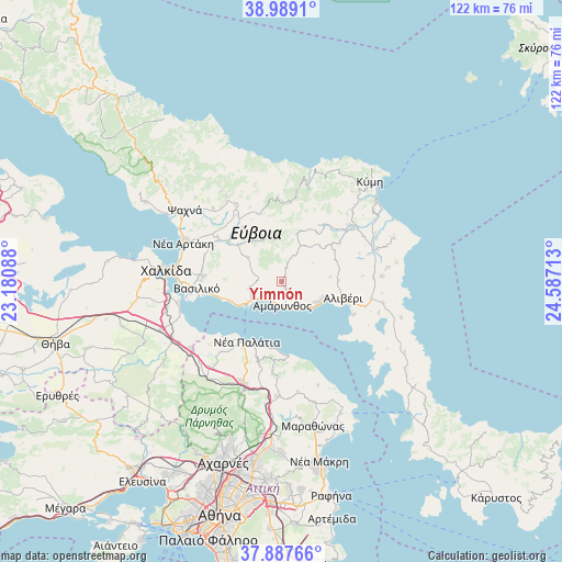
Yimnón GPS coordinates[2]
38° 26' 25.728" North, 23° 53' 2.4" East
| Map corner | latitude | longitude |
|---|---|---|
| Upper-left | 38.9891°, | 23.18088° |
| Center: | 38.44048°, | 23.884° |
| Lower-right: | 37.88766°, | 24.58713° |
| Map W x H: | 122.5×122.5 km | = 76.1×76.1mi |
| max Lat: | 41.72048° ⇑62.7% North |
| Yimnón: | 38.44048° |
| min Lat: | ⇓37.3% South 34.8346° |
| min Long | Yimnón | max Long |
| 19.40494° | 23.884° | 29.59361° |
| W 75.9%⇐ | ⇒24.1% E |
Elevation
Elevation of Yimnón is 146 m = 479 ft, and this is 22.9 m = 75 ft below average elevation for this country.
| Max E: |
1439 m = 4721 ft | 33.3% |
| Avg. | 168.9 m = 554 ft | |
| Yimnón | 146 m = 479 ft | |
Min E: |
0 m = 0 ft | 66.7% |
See also: Greece elevation on elevation.city.
Geographical zone
Yimnón is located in North temperate zone (between Tropic of Cancer and the Arctic Circle). Distance of this Northern Tropic circle is 1668.3 km =1036.6 mi to South.| Distance of | km | miles | from Yimnón |
|---|---|---|---|
| North Pole | 5732.9 | 3562.3 | to North |
| Arctic Circle | 3127 | 1943 | to North |
| Tropic Cancer | 1668.3 | 1036.6 | to South |
| Equator | 4274.2 | 2655.9 | to South |


Nearby cities:
15 places around Yimnón: (largest is in red/bold)
• Afrátion
17.1 km =10.6 mi,  274°
274°
• Alivéri
13.3 km =8.3 mi,  101°
101°
• Amárynthos
5.3 km =3.3 mi,  179°
179°
• Erétria
8.4 km =5.2 mi,  238°
238°
• Fílla
17.5 km =10.9 mi, 270°
• Kálamos
17.4 km =10.8 mi,  186°
186°
• Magoúla
6.3 km =3.9 mi, 239°
• Malakónta
11.2 km =7 mi,  246°
246°
• Markópoulo Oropoú
17.5 km =10.9 mi,  197°
197°
• Néa Palátia
15.5 km =9.6 mi,  209°
209°
• Néa Politeía
17.6 km =10.9 mi, 208°
• Skála Oropoú
15.8 km =9.8 mi, 212°
• Ágios Loukás
12.2 km =7.6 mi,  89°
89°
• Áyioi Apóstoloi
16.7 km =10.4 mi,  172°
172°
• Áyios Ioánnis
10.6 km =6.6 mi, 85°
Sources, notices
• [Note1] Compared only with cities in Greece existing in our database
• [Src1] Map data: © OpenStreetMap contributors (CC-BY-SA)
• [Src2] Other city data from geonames.org with taken over terms of usage.
• [Src3] Geographical zone / Annual Mean Temperature by Robert A. Rohde @ Wikipedia
