Alivéri geodata
Alivéri (Central Greece) is a seat of a third-order administrative division; located in Greece in Europe/Athens (GMT+3) time zone. With population of 5,184 people, there are 230 cities with bigger population in this country. Compared to other cities in Greece, 63.3% of cities are located further ↑North; 79.4% of cities are located further ←West and 60.6% of cities have higher elevation than Alivéri. Note1
Administrative division(s):
- Level 1: Central Greece
- Level 2: Nomós Evvoías
- Level 3: Dimos Kymi-Aliveri


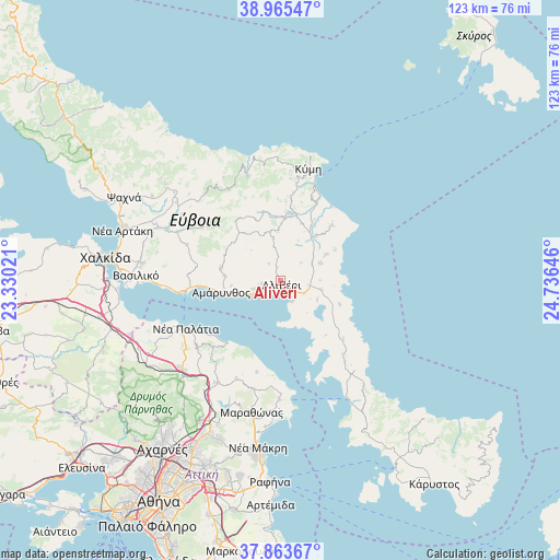
Alivéri GPS coordinates[2]
38° 25' 0.012" North, 24° 1' 59.988" East
| Map corner | latitude | longitude |
|---|---|---|
| Upper-left | 38.96547°, | 23.33021° |
| Center: | 38.41667°, | 24.03333° |
| Lower-right: | 37.86367°, | 24.73646° |
| Map W x H: | 122.5×122.5 km | = 76.1×76.1mi |
| max Lat: | 41.72048° ⇑63.3% North |
| Alivéri: | 38.41667° |
| min Lat: | ⇓36.7% South 34.8346° |
| min Long | Alivéri | max Long |
| 19.40494° | 24.03333° | 29.59361° |
| W 79.4%⇐ | ⇒20.6% E |
Elevation
Elevation of Alivéri is 48 m = 157 ft, and this is 120.9 m = 397 ft below average elevation for this country.
| Max E: |
1439 m = 4721 ft | 60.6% |
| Avg. | 168.9 m = 554 ft | |
| Alivéri | 48 m = 157 ft | |
Min E: |
0 m = 0 ft | 39.4% |
See also: Greece elevation on elevation.city.
Geographical zone
Alivéri is located in North temperate zone (between Tropic of Cancer and the Arctic Circle). Distance of this Northern Tropic circle is 1665.6 km =1035 mi to South.| Distance of | km | miles | from Alivéri |
|---|---|---|---|
| North Pole | 5735.5 | 3563.9 | to North |
| Arctic Circle | 3129.6 | 1944.6 | to North |
| Tropic Cancer | 1665.6 | 1035 | to South |
| Equator | 4271.5 | 2654.2 | to South |


Nearby cities:
15 places around Alivéri: (largest is in red/bold)
• Amárynthos
13.2 km =8.2 mi,  258°
258°
• Erétria
20.2 km =12.6 mi,  265°
265°
• Kálamos
20.9 km =13 mi,  225°
225°
• Magoúla
18.5 km =11.5 mi, 268°
• Malakónta
23.3 km =14.5 mi, 265°
• Markópoulo Oropoú
23 km =14.3 mi, 232°
• Mikrokhórion
23.7 km =14.7 mi,  210°
210°
• Néa Palátia
23.3 km =14.5 mi,  242°
242°
• Oxílithos
19.4 km =12.1 mi,  20°
20°
• Varnávas
23.5 km =14.6 mi,  204°
204°
• Yimnón
13.3 km =8.3 mi,  281°
281°
• Zárakes
18.8 km =11.7 mi,  132°
132°
• Ágios Loukás
2.9 km =1.8 mi,  344°
344°
• Áyioi Apóstoloi
17.6 km =10.9 mi,  217°
217°
• Áyios Ioánnis
4.3 km =2.7 mi,  324°
324°
Sources, notices
• [Note1] Compared only with cities in Greece existing in our database
• [Src1] Map data: © OpenStreetMap contributors (CC-BY-SA)
• [Src2] Other city data from geonames.org with taken over terms of usage.
• [Src3] Geographical zone / Annual Mean Temperature by Robert A. Rohde @ Wikipedia
