Magoúla geodata
Magoúla (Central Greece) is a populated place; located in Greece in Europe/Athens (GMT+3) time zone. With population of 1,063 people, there are 950 cities with bigger population in this country. Compared to other cities in Greece, 63.5% of cities are located further ↑North; 73.8% of cities are located further ←West and 68.3% of cities have higher elevation than Magoúla. Note1


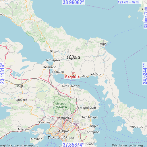
Magoúla GPS coordinates[2]
38° 24' 42.408" North, 23° 49' 16.608" East
| Map corner | latitude | longitude |
|---|---|---|
| Upper-left | 38.96062°, | 23.11816° |
| Center: | 38.41178°, | 23.82128° |
| Lower-right: | 37.85874°, | 24.52441° |
| Map W x H: | 122.5×122.5 km | = 76.1×76.1mi |
| max Lat: | 41.72048° ⇑63.5% North |
| Magoúla: | 38.41178° |
| min Lat: | ⇓36.5% South 34.8346° |
| min Long | Magoúla | max Long |
| 19.40494° | 23.82128° | 29.59361° |
| W 73.8%⇐ | ⇒26.2% E |
Elevation
Elevation of Magoúla is 34 m = 112 ft, and this is 134.9 m = 443 ft below average elevation for this country.
| Max E: |
1439 m = 4721 ft | 68.3% |
| Avg. | 168.9 m = 554 ft | |
| Magoúla | 34 m = 112 ft | |
Min E: |
0 m = 0 ft | 31.7% |
See also: Greece elevation on elevation.city.
Geographical zone
Magoúla is located in North temperate zone (between Tropic of Cancer and the Arctic Circle). Distance of this Northern Tropic circle is 1665.1 km =1034.6 mi to South.| Distance of | km | miles | from Magoúla |
|---|---|---|---|
| North Pole | 5736.1 | 3564.2 | to North |
| Arctic Circle | 3130.2 | 1945 | to North |
| Tropic Cancer | 1665.1 | 1034.6 | to South |
| Equator | 4271 | 2653.9 | to South |


Nearby cities:
15 places around Magoúla: (largest is in red/bold)
• Afrátion
12.5 km =7.8 mi,  291°
291°
• Amárynthos
5.9 km =3.7 mi,  110°
110°
• Erétria
2.1 km =1.3 mi,  234°
234°
• Fílla
12.5 km =7.8 mi, 285°
• Khalkoútsion
11.8 km =7.3 mi,  221°
221°
• Kálamos
14.6 km =9.1 mi,  165°
165°
• Malakónta
4.9 km =3 mi,  254°
254°
• Markópoulo Oropoú
13.6 km =8.5 mi,  178°
178°
• Néa Palátia
10.5 km =6.5 mi,  191°
191°
• Néa Politeía
12.6 km =7.8 mi, 194°
• Oropós
13.4 km =8.3 mi,  205°
205°
• Skála Oropoú
10.7 km =6.6 mi,  195°
195°
• Sykámino
14.5 km =9 mi, 213°
• Vasilikón
13.1 km =8.1 mi,  276°
276°
• Yimnón
6.3 km =3.9 mi,  59°
59°
Sources, notices
• [Note1] Compared only with cities in Greece existing in our database
• [Src1] Map data: © OpenStreetMap contributors (CC-BY-SA)
• [Src2] Other city data from geonames.org with taken over terms of usage.
• [Src3] Geographical zone / Annual Mean Temperature by Robert A. Rohde @ Wikipedia
