Malakónta geodata
Malakónta (Central Greece) is a populated place; located in Greece in Europe/Athens (GMT+3) time zone. With population of 1,097 people, there are 925 cities with bigger population in this country. Compared to other cities in Greece, 63.8% of cities are located further ↑North; 72% of cities are located further ←West and 72.2% of cities have higher elevation than Malakónta. Note1


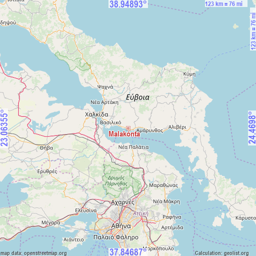
Malakónta GPS coordinates[2]
38° 24' 0" North, 23° 46' 0.012" East
| Map corner | latitude | longitude |
|---|---|---|
| Upper-left | 38.94893°, | 23.06355° |
| Center: | 38.4°, | 23.76667° |
| Lower-right: | 37.84687°, | 24.4698° |
| Map W x H: | 122.5×122.5 km | = 76.1×76.1mi |
| max Lat: | 41.72048° ⇑63.8% North |
| Malakónta: | 38.4° |
| min Lat: | ⇓36.2% South 34.8346° |
| min Long | Malakónta | max Long |
| 19.40494° | 23.76667° | 29.59361° |
| W 72%⇐ | ⇒28% E |
Elevation
Elevation of Malakónta is 27 m = 89 ft, and this is 141.9 m = 466 ft below average elevation for this country.
| Max E: |
1439 m = 4721 ft | 72.2% |
| Avg. | 168.9 m = 554 ft | |
| Malakónta | 27 m = 89 ft | |
Min E: |
0 m = 0 ft | 27.8% |
See also: Greece elevation on elevation.city.
Geographical zone
Malakónta is located in North temperate zone (between Tropic of Cancer and the Arctic Circle). Distance of this Northern Tropic circle is 1663.8 km =1033.8 mi to South.| Distance of | km | miles | from Malakónta |
|---|---|---|---|
| North Pole | 5737.4 | 3565.1 | to North |
| Arctic Circle | 3131.5 | 1945.8 | to North |
| Tropic Cancer | 1663.8 | 1033.8 | to South |
| Equator | 4269.7 | 2653.1 | to South |


Nearby cities:
15 places around Malakónta: (largest is in red/bold)
• Afrátion
9 km =5.6 mi,  310°
310°
• Amárynthos
10.3 km =6.4 mi,  94°
94°
• Dílesi
10.9 km =6.8 mi,  230°
230°
• Erétria
3.1 km =1.9 mi, 88°
• Fílla
8.6 km =5.3 mi,  302°
302°
• Khalkoútsion
8.1 km =5 mi,  202°
202°
• Magoúla
4.9 km =3 mi,  74°
74°
• Mytikas
11 km =6.8 mi, 296°
• Néa Palátia
9.3 km =5.8 mi,  163°
163°
• Néa Politeía
11 km =6.8 mi,  171°
171°
• Oropós
10.8 km =6.7 mi,  185°
185°
• Skála Oropoú
9.1 km =5.7 mi, 168°
• Vasilikón
8.7 km =5.4 mi,  289°
289°
• Yimnón
11.2 km =7 mi, 66°
• Áyios Nikólaos
10.6 km =6.6 mi,  282°
282°
Sources, notices
• [Note1] Compared only with cities in Greece existing in our database
• [Src1] Map data: © OpenStreetMap contributors (CC-BY-SA)
• [Src2] Other city data from geonames.org with taken over terms of usage.
• [Src3] Geographical zone / Annual Mean Temperature by Robert A. Rohde @ Wikipedia
