Traganón geodata
Traganón (Peloponnese) is a populated place; located in Greece in Europe/Athens (GMT+3) time zone. With population of 2,414 people, there are 433 cities with bigger population in this country. Compared to other cities in Greece, 77.9% of cities are located further ↑North; 85.9% of cities are located further →East and 75.5% of cities have higher elevation than Traganón. Note1


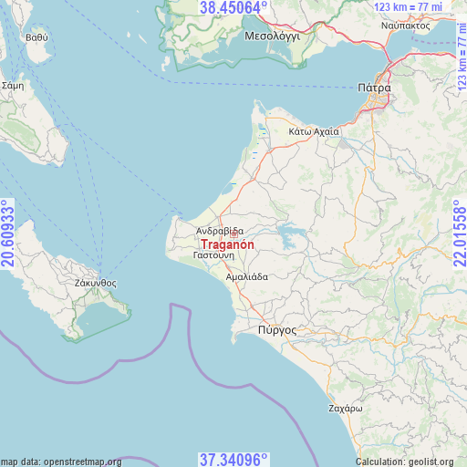
Traganón GPS coordinates[2]
37° 53' 52.404" North, 21° 18' 44.82" East
| Map corner | latitude | longitude |
|---|---|---|
| Upper-left | 38.45064°, | 20.60933° |
| Center: | 37.89789°, | 21.31245° |
| Lower-right: | 37.34096°, | 22.01558° |
| Map W x H: | 123.4×123.4 km | = 76.7×76.7mi |
| max Lat: | 41.72048° ⇑77.9% North |
| Traganón: | 37.89789° |
| min Lat: | ⇓22.1% South 34.8346° |
| min Long | Traganón | max Long |
| 19.40494° | 21.31245° | 29.59361° |
| W 14.1%⇐ | ⇒85.9% E |
Elevation
Elevation of Traganón is 23 m = 75 ft, and this is 145.9 m = 479 ft below average elevation for this country.
| Max E: |
1439 m = 4721 ft | 75.5% |
| Avg. | 168.9 m = 554 ft | |
| Traganón | 23 m = 75 ft | |
Min E: |
0 m = 0 ft | 24.5% |
See also: Greece elevation on elevation.city.
Geographical zone
Traganón is located in North temperate zone (between Tropic of Cancer and the Arctic Circle). Distance of this Northern Tropic circle is 1607.9 km =999.1 mi to South.| Distance of | km | miles | from Traganón |
|---|---|---|---|
| North Pole | 5793.2 | 3599.7 | to North |
| Arctic Circle | 3187.3 | 1980.5 | to North |
| Tropic Cancer | 1607.9 | 999.1 | to South |
| Equator | 4213.9 | 2618.4 | to South |


Nearby cities:
15 places around Traganón: (largest is in red/bold)
• Amaliáda
11.6 km =7.2 mi,  163°
163°
• Andravída
3.9 km =2.4 mi,  283°
283°
• Chávari
8.4 km =5.2 mi,  131°
131°
• Gastoúni
7.6 km =4.7 mi,  225°
225°
• Kardamás
14.7 km =9.1 mi,  170°
170°
• Kavásila
4.9 km =3 mi,  239°
239°
• Kyllíni
15.3 km =9.5 mi,  285°
285°
• Káto Panagía
14.9 km =9.3 mi, 283°
• Lechainá
5.6 km =3.5 mi,  314°
314°
• Myrsíni
7.1 km =4.4 mi, 291°
• Neochóri
9.6 km =6 mi, 276°
• Savália
8.6 km =5.3 mi,  190°
190°
• Synoikismós Chavaríou
8.1 km =5 mi, 125°
• Vartholomió
10.2 km =6.3 mi,  247°
247°
• Íkaros
12.2 km =7.6 mi, 281°
Sources, notices
• [Note1] Compared only with cities in Greece existing in our database
• [Src1] Map data: © OpenStreetMap contributors (CC-BY-SA)
• [Src2] Other city data from geonames.org with taken over terms of usage.
• [Src3] Geographical zone / Annual Mean Temperature by Robert A. Rohde @ Wikipedia
