Kavásila geodata
Kavásila (West Greece) is a populated place; located in Greece in Europe/Athens (GMT+3) time zone. With population of 1,623 people, there are 615 cities with bigger population in this country. Compared to other cities in Greece, 78.3% of cities are located further ↑North; 86.7% of cities are located further →East and 84.7% of cities have higher elevation than Kavásila. Note1


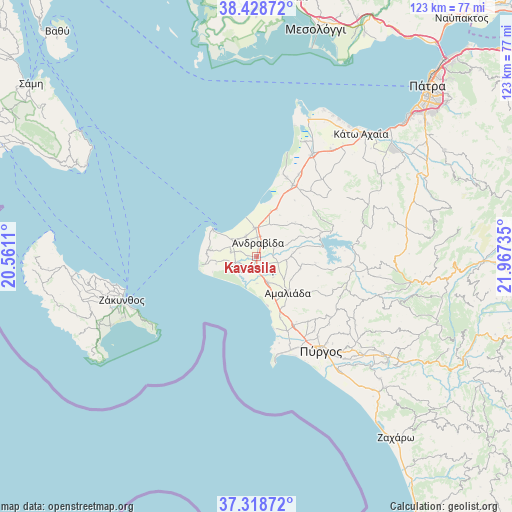
Kavásila GPS coordinates[2]
37° 52' 32.916" North, 21° 15' 51.192" East
| Map corner | latitude | longitude |
|---|---|---|
| Upper-left | 38.42872°, | 20.5611° |
| Center: | 37.87581°, | 21.26422° |
| Lower-right: | 37.31872°, | 21.96735° |
| Map W x H: | 123.4×123.4 km | = 76.7×76.7mi |
| max Lat: | 41.72048° ⇑78.3% North |
| Kavásila: | 37.87581° |
| min Lat: | ⇓21.7% South 34.8346° |
| min Long | Kavásila | max Long |
| 19.40494° | 21.26422° | 29.59361° |
| W 13.3%⇐ | ⇒86.7% E |
Elevation
Elevation of Kavásila is 13 m = 43 ft, and this is 155.9 m = 511 ft below average elevation for this country.
| Max E: |
1439 m = 4721 ft | 84.7% |
| Avg. | 168.9 m = 554 ft | |
| Kavásila | 13 m = 43 ft | |
Min E: |
0 m = 0 ft | 15.3% |
See also: Greece elevation on elevation.city.
Geographical zone
Kavásila is located in North temperate zone (between Tropic of Cancer and the Arctic Circle). Distance of this Northern Tropic circle is 1605.5 km =997.6 mi to South.| Distance of | km | miles | from Kavásila |
|---|---|---|---|
| North Pole | 5795.7 | 3601.3 | to North |
| Arctic Circle | 3189.8 | 1982 | to North |
| Tropic Cancer | 1605.5 | 997.6 | to South |
| Equator | 4211.4 | 2616.8 | to South |


Nearby cities:
15 places around Kavásila: (largest is in red/bold)
• Amaliáda
11.5 km =7.1 mi,  138°
138°
• Andravída
3.4 km =2.1 mi,  7°
7°
• Chávari
10.9 km =6.8 mi,  106°
106°
• Gastoúni
3.1 km =1.9 mi,  203°
203°
• Kardamás
13.8 km =8.6 mi,  151°
151°
• Kyllíni
12.4 km =7.7 mi,  302°
302°
• Káto Panagía
11.9 km =7.4 mi, 300°
• Lechainá
6.4 km =4 mi,  1°
1°
• Myrsíni
5.6 km =3.5 mi,  334°
334°
• Neochóri
6.4 km =4 mi, 304°
• Savália
6.6 km =4.1 mi,  156°
156°
• Synoikismós Chavaríou
11.1 km =6.9 mi,  101°
101°
• Traganón
4.9 km =3 mi,  59°
59°
• Vartholomió
5.4 km =3.4 mi,  253°
253°
• Íkaros
9.2 km =5.7 mi, 302°
Sources, notices
• [Note1] Compared only with cities in Greece existing in our database
• [Src1] Map data: © OpenStreetMap contributors (CC-BY-SA)
• [Src2] Other city data from geonames.org with taken over terms of usage.
• [Src3] Geographical zone / Annual Mean Temperature by Robert A. Rohde @ Wikipedia
