Stournaraíïka geodata
Stournaraíïka (Thessaly) is a populated place; located in Greece in Europe/Athens (GMT+3) time zone. With population of 537 people, there are 1724 cities with bigger population in this country. Compared to other cities in Greece, 55.1% of cities are located further ↓South; 83.2% of cities are located further →East and 98.1% of cities have lower elevation than Stournaraíïka. Note1


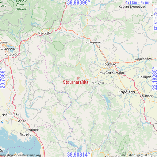
Stournaraíïka GPS coordinates[2]
39° 27' 11.412" North, 21° 29' 22.992" East
| Map corner | latitude | longitude |
|---|---|---|
| Upper-left | 39.99396°, | 20.7866° |
| Center: | 39.45317°, | 21.48972° |
| Lower-right: | 38.90814°, | 22.19285° |
| Map W x H: | 120.7×120.7 km | = 75×75mi |
| max Lat: | 41.72048° ⇑44.9% North |
| Stournaraíïka: | 39.45317° |
| min Lat: | ⇓55.1% South 34.8346° |
| min Long | Stournaraíïka | max Long |
| 19.40494° | 21.48972° | 29.59361° |
| W 16.8%⇐ | ⇒83.2% E |
Elevation
Elevation of Stournaraíïka is 855 m = 2805 ft, and this is 686.1 m = 2251 ft above average elevation for this country.
| Max E: |
1439 m = 4721 ft | 1.9% |
| Stournaraíïka | 855 m 2805 ft | |
| Avg. | 168.9 m = 554 ft | |
Min E: |
0 m = 0 ft | 98.1% |
See also: Greece elevation on elevation.city.
Geographical zone
Stournaraíïka is located in North temperate zone (between Tropic of Cancer and the Arctic Circle). Distance of this Northern Tropic circle is 1780.9 km =1106.6 mi to South.| Distance of | km | miles | from Stournaraíïka |
|---|---|---|---|
| North Pole | 5620.3 | 3492.3 | to North |
| Arctic Circle | 3014.4 | 1873.1 | to North |
| Tropic Cancer | 1780.9 | 1106.6 | to South |
| Equator | 4386.8 | 2725.8 | to South |


Nearby cities:
15 places around Stournaraíïka: (largest is in red/bold)
• Anthiró
12.1 km =7.5 mi,  192°
192°
• Dendrochóri
16.8 km =10.4 mi,  48°
48°
• Drakótrypa
11.2 km =7 mi,  123°
123°
• Eleftherochóri
14.9 km =9.3 mi,  56°
56°
• Eláti
6.8 km =4.2 mi,  38°
38°
• Fíki
15.9 km =9.9 mi, 63°
• Gorgogýri
13.5 km =8.4 mi, 38°
• Mouzáki
15.2 km =9.4 mi,  99°
99°
• Palaiomonástiro
14.5 km =9 mi,  85°
85°
• Piáleia
10.8 km =6.7 mi, 57°
• Prínos
16.6 km =10.3 mi, 38°
• Pródromos
15.1 km =9.4 mi,  34°
34°
• Pýli
11.1 km =6.9 mi, 87°
• Vatsouniá
9.5 km =5.9 mi, 120°
• Ágios Vissaríonas
11.3 km =7 mi,  79°
79°
Sources, notices
• [Note1] Compared only with cities in Greece existing in our database
• [Src1] Map data: © OpenStreetMap contributors (CC-BY-SA)
• [Src2] Other city data from geonames.org with taken over terms of usage.
• [Src3] Geographical zone / Annual Mean Temperature by Robert A. Rohde @ Wikipedia
