Fíki geodata
Fíki (Thessaly) is a populated place; located in Greece in Europe/Athens (GMT+3) time zone. With population of 1,098 people, there are 920 cities with bigger population in this country. Compared to other cities in Greece, 56.9% of cities are located further ↓South; 79.7% of cities are located further →East and 63.1% of cities have lower elevation than Fíki. Note1


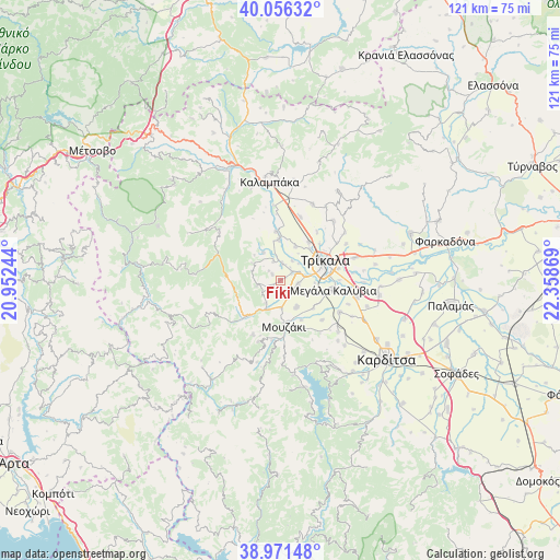
Fíki GPS coordinates[2]
39° 30' 57.672" North, 21° 39' 20.016" East
| Map corner | latitude | longitude |
|---|---|---|
| Upper-left | 40.05632°, | 20.95244° |
| Center: | 39.51602°, | 21.65556° |
| Lower-right: | 38.97148°, | 22.35869° |
| Map W x H: | 120.6×120.6 km | = 74.9×74.9mi |
| max Lat: | 41.72048° ⇑43.1% North |
| Fíki: | 39.51602° |
| min Lat: | ⇓56.9% South 34.8346° |
| min Long | Fíki | max Long |
| 19.40494° | 21.65556° | 29.59361° |
| W 20.3%⇐ | ⇒79.7% E |
Elevation
Elevation of Fíki is 132 m = 433 ft, and this is 36.9 m = 121 ft below average elevation for this country.
| Max E: |
1439 m = 4721 ft | 36.9% |
| Avg. | 168.9 m = 554 ft | |
| Fíki | 132 m = 433 ft | |
Min E: |
0 m = 0 ft | 63.1% |
See also: Greece elevation on elevation.city.
Geographical zone
Fíki is located in North temperate zone (between Tropic of Cancer and the Arctic Circle). Distance of this Northern Tropic circle is 1787.9 km =1110.9 mi to South.| Distance of | km | miles | from Fíki |
|---|---|---|---|
| North Pole | 5613.3 | 3487.9 | to North |
| Arctic Circle | 3007.4 | 1868.7 | to North |
| Tropic Cancer | 1787.9 | 1110.9 | to South |
| Equator | 4393.8 | 2730.2 | to South |


Nearby cities:
15 places around Fíki: (largest is in red/bold)
• Dendrochóri
4.4 km =2.7 mi,  338°
338°
• Droseró
7.4 km =4.6 mi,  94°
94°
• Eleftherochóri
2.2 km =1.4 mi,  305°
305°
• Gorgogýri
6.8 km =4.2 mi,  301°
301°
• Gómfoi
6.6 km =4.1 mi,  150°
150°
• Lygariá
3.4 km =2.1 mi,  134°
134°
• Mouriá
6.1 km =3.8 mi,  119°
119°
• Palaiomonástiro
5.9 km =3.7 mi,  178°
178°
• Pigí
3.9 km =2.4 mi,  98°
98°
• Piáleia
5.3 km =3.3 mi,  257°
257°
• Prínos
7 km =4.3 mi,  327°
327°
• Pródromos
7.8 km =4.8 mi, 313°
• Pýli
7.2 km =4.5 mi,  206°
206°
• Valtinó
3.6 km =2.2 mi,  6°
6°
• Ágios Vissaríonas
5.9 km =3.7 mi, 211°
Sources, notices
• [Note1] Compared only with cities in Greece existing in our database
• [Src1] Map data: © OpenStreetMap contributors (CC-BY-SA)
• [Src2] Other city data from geonames.org with taken over terms of usage.
• [Src3] Geographical zone / Annual Mean Temperature by Robert A. Rohde @ Wikipedia
