Dendrochóri geodata
Dendrochóri (Thessaly) is a populated place; located in Greece in Europe/Athens (GMT+3) time zone. With population of 568 people, there are 1654 cities with bigger population in this country. Compared to other cities in Greece, 57.9% of cities are located further ↓South; 80.1% of cities are located further →East and 61.4% of cities have lower elevation than Dendrochóri. Note1


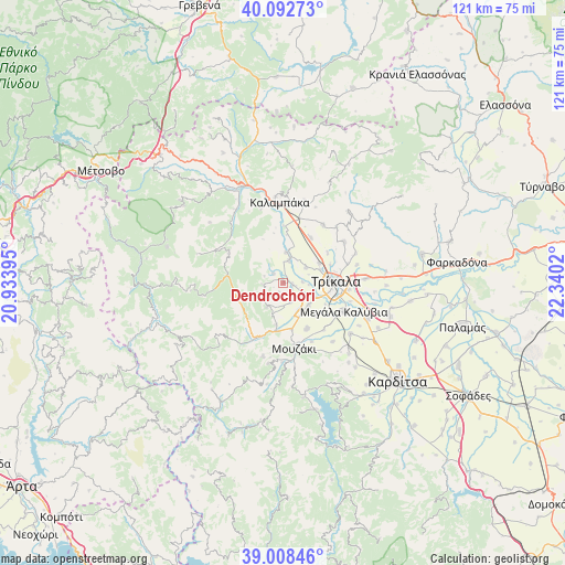
Dendrochóri GPS coordinates[2]
39° 33' 9.756" North, 21° 38' 13.452" East
| Map corner | latitude | longitude |
|---|---|---|
| Upper-left | 40.09273°, | 20.93395° |
| Center: | 39.55271°, | 21.63707° |
| Lower-right: | 39.00846°, | 22.3402° |
| Map W x H: | 120.6×120.6 km | = 74.9×74.9mi |
| max Lat: | 41.72048° ⇑42.1% North |
| Dendrochóri: | 39.55271° |
| min Lat: | ⇓57.9% South 34.8346° |
| min Long | Dendrochóri | max Long |
| 19.40494° | 21.63707° | 29.59361° |
| W 19.9%⇐ | ⇒80.1% E |
Elevation
Elevation of Dendrochóri is 123 m = 404 ft, and this is 45.9 m = 151 ft below average elevation for this country.
| Max E: |
1439 m = 4721 ft | 38.6% |
| Avg. | 168.9 m = 554 ft | |
| Dendrochóri | 123 m = 404 ft | |
Min E: |
0 m = 0 ft | 61.4% |
See also: Greece elevation on elevation.city.
Geographical zone
Dendrochóri is located in North temperate zone (between Tropic of Cancer and the Arctic Circle). Distance of this Northern Tropic circle is 1791.9 km =1113.4 mi to South.| Distance of | km | miles | from Dendrochóri |
|---|---|---|---|
| North Pole | 5609.2 | 3485.4 | to North |
| Arctic Circle | 3003.3 | 1866.2 | to North |
| Tropic Cancer | 1791.9 | 1113.4 | to South |
| Equator | 4397.8 | 2732.7 | to South |


Nearby cities:
15 places around Dendrochóri: (largest is in red/bold)
• Dialektó
4.8 km =3 mi,  15°
15°
• Eleftherochóri
2.8 km =1.7 mi,  184°
184°
• Fíki
4.4 km =2.7 mi,  158°
158°
• Gorgogýri
4.2 km =2.6 mi,  262°
262°
• Kefalóvryso
5.7 km =3.5 mi,  56°
56°
• Lygariá
7.6 km =4.7 mi,  148°
148°
• Megárchis
6.5 km =4 mi,  4°
4°
• Méga Kefalóvryso
8.8 km =5.5 mi, 62°
• Pigí
7.2 km =4.5 mi,  130°
130°
• Piáleia
6.4 km =4 mi,  214°
214°
• Prínos
2.9 km =1.8 mi,  310°
310°
• Pródromos
4.3 km =2.7 mi,  288°
288°
• Pyrgetós
9.5 km =5.9 mi,  89°
89°
• Valtinó
2 km =1.2 mi,  103°
103°
• Ágios Vissaríonas
9.2 km =5.7 mi,  189°
189°
Sources, notices
• [Note1] Compared only with cities in Greece existing in our database
• [Src1] Map data: © OpenStreetMap contributors (CC-BY-SA)
• [Src2] Other city data from geonames.org with taken over terms of usage.
• [Src3] Geographical zone / Annual Mean Temperature by Robert A. Rohde @ Wikipedia
