Stefanovíkeio geodata
Stefanovíkeio (Thessaly) is a populated place; located in Greece in Europe/Athens (GMT+3) time zone. With population of 1,970 people, there are 526 cities with bigger population in this country. Compared to other cities in Greece, 55.5% of cities are located further ↓South; 53.7% of cities are located further →East and 58.1% of cities have higher elevation than Stefanovíkeio. Note1


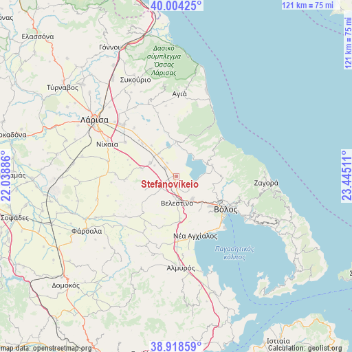
Stefanovíkeio GPS coordinates[2]
39° 27' 48.744" North, 22° 44' 31.128" East
| Map corner | latitude | longitude |
|---|---|---|
| Upper-left | 40.00425°, | 22.03886° |
| Center: | 39.46354°, | 22.74198° |
| Lower-right: | 38.91859°, | 23.44511° |
| Map W x H: | 120.7×120.7 km | = 75×75mi |
| max Lat: | 41.72048° ⇑44.5% North |
| Stefanovíkeio: | 39.46354° |
| min Lat: | ⇓55.5% South 34.8346° |
| min Long | Stefanovíkeio | max Long |
| 19.40494° | 22.74198° | 29.59361° |
| W 46.3%⇐ | ⇒53.7% E |
Elevation
Elevation of Stefanovíkeio is 56 m = 184 ft, and this is 112.9 m = 370 ft below average elevation for this country.
| Max E: |
1439 m = 4721 ft | 58.1% |
| Avg. | 168.9 m = 554 ft | |
| Stefanovíkeio | 56 m = 184 ft | |
Min E: |
0 m = 0 ft | 41.9% |
See also: Greece elevation on elevation.city.
Geographical zone
Stefanovíkeio is located in North temperate zone (between Tropic of Cancer and the Arctic Circle). Distance of this Northern Tropic circle is 1782 km =1107.3 mi to South.| Distance of | km | miles | from Stefanovíkeio |
|---|---|---|---|
| North Pole | 5619.1 | 3491.5 | to North |
| Arctic Circle | 3013.2 | 1872.3 | to North |
| Tropic Cancer | 1782 | 1107.3 | to South |
| Equator | 4387.9 | 2726.5 | to South |


Nearby cities:
15 places around Stefanovíkeio: (largest is in red/bold)
• Anakasiá
22 km =13.7 mi,  114°
114°
• Arméni
4.7 km =2.9 mi,  305°
305°
• Chálki
20.9 km =13 mi,  303°
303°
• Kanália
13 km =8.1 mi,  72°
72°
• Makrinítsa
22.2 km =13.8 mi, 108°
• Néa Anchiálos
21.4 km =13.3 mi,  162°
162°
• Néa Ionía
18.5 km =11.5 mi,  120°
120°
• Platýkampos
24.7 km =15.3 mi, 313°
• Portariá
23.6 km =14.7 mi, 110°
• Rizómylos
4 km =2.5 mi,  173°
173°
• Velestíno
9.1 km =5.7 mi,  177°
177°
• Volos
20.7 km =12.9 mi, 123°
• Ágios Geórgios Ferón
10.9 km =6.8 mi, 163°
• Álli Meriá
23.2 km =14.4 mi, 116°
• Áno Vólos
22.6 km =14 mi, 114°
Sources, notices
• [Note1] Compared only with cities in Greece existing in our database
• [Src1] Map data: © OpenStreetMap contributors (CC-BY-SA)
• [Src2] Other city data from geonames.org with taken over terms of usage.
• [Src3] Geographical zone / Annual Mean Temperature by Robert A. Rohde @ Wikipedia
