Stavrós geodata
Stavrós (Thessaly) is a populated place; located in Greece in Europe/Athens (GMT+3) time zone. With population of 954 people, there are 1068 cities with bigger population in this country. Compared to other cities in Greece, 52.9% of cities are located further ↓South; 72.9% of cities are located further →East and 56.5% of cities have lower elevation than Stavrós. Note1


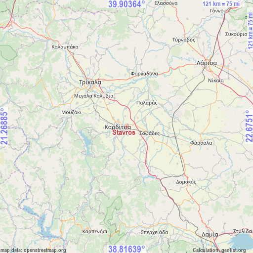
Stavrós GPS coordinates[2]
39° 21' 43.668" North, 21° 58' 19.092" East
| Map corner | latitude | longitude |
|---|---|---|
| Upper-left | 39.90364°, | 21.26885° |
| Center: | 39.36213°, | 21.97197° |
| Lower-right: | 38.81639°, | 22.6751° |
| Map W x H: | 120.9×120.9 km | = 75.1×75.1mi |
| max Lat: | 41.72048° ⇑47.1% North |
| Stavrós: | 39.36213° |
| min Lat: | ⇓52.9% South 34.8346° |
| min Long | Stavrós | max Long |
| 19.40494° | 21.97197° | 29.59361° |
| W 27.1%⇐ | ⇒72.9% E |
Elevation
Elevation of Stavrós is 103 m = 338 ft, and this is 65.9 m = 216 ft below average elevation for this country.
| Max E: |
1439 m = 4721 ft | 43.5% |
| Avg. | 168.9 m = 554 ft | |
| Stavrós | 103 m = 338 ft | |
Min E: |
0 m = 0 ft | 56.5% |
See also: Greece elevation on elevation.city.
Geographical zone
Stavrós is located in North temperate zone (between Tropic of Cancer and the Arctic Circle). Distance of this Northern Tropic circle is 1770.7 km =1100.3 mi to South.| Distance of | km | miles | from Stavrós |
|---|---|---|---|
| North Pole | 5630.4 | 3498.6 | to North |
| Arctic Circle | 3024.5 | 1879.3 | to North |
| Tropic Cancer | 1770.7 | 1100.3 | to South |
| Equator | 4376.7 | 2719.6 | to South |


Nearby cities:
15 places around Stavrós: (largest is in red/bold)
• Artesianó
7.9 km =4.9 mi,  304°
304°
• Georgikó
10 km =6.2 mi,  250°
250°
• Kallifóni
9.5 km =5.9 mi,  185°
185°
• Kallíthiro
10.7 km =6.6 mi,  212°
212°
• Karditsomagoúla
5.2 km =3.2 mi,  307°
307°
• Kardítsa
4.3 km =2.7 mi,  274°
274°
• Karpochóri
4.5 km =2.8 mi,  130°
130°
• Krýa Vrýsi
9.5 km =5.9 mi,  243°
243°
• Makrychóri
8.7 km =5.4 mi,  356°
356°
• Mavrika
3.4 km =2.1 mi,  230°
230°
• Mýrina
5.1 km =3.2 mi,  351°
351°
• Palaiokklísi
9.4 km =5.8 mi,  279°
279°
• Pródromos
1.5 km =0.9 mi,  9°
9°
• Roússo
8.1 km =5 mi, 226°
• Zaḯmi
7.5 km =4.7 mi,  202°
202°
Sources, notices
• [Note1] Compared only with cities in Greece existing in our database
• [Src1] Map data: © OpenStreetMap contributors (CC-BY-SA)
• [Src2] Other city data from geonames.org with taken over terms of usage.
• [Src3] Geographical zone / Annual Mean Temperature by Robert A. Rohde @ Wikipedia
