Kallíthiro geodata
Kallíthiro (Thessaly) is a populated place; located in Greece in Europe/Athens (GMT+3) time zone. With population of 1,098 people, there are 920 cities with bigger population in this country. Compared to other cities in Greece, 51% of cities are located further ↓South; 74.1% of cities are located further →East and 70% of cities have lower elevation than Kallíthiro. Note1


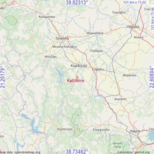
Kallíthiro GPS coordinates[2]
39° 16' 51.564" North, 21° 54' 17.676" East
| Map corner | latitude | longitude |
|---|---|---|
| Upper-left | 39.82313°, | 21.20179° |
| Center: | 39.28099°, | 21.90491° |
| Lower-right: | 38.73462°, | 22.60804° |
| Map W x H: | 121×121 km | = 75.2×75.2mi |
| max Lat: | 41.72048° ⇑49% North |
| Kallíthiro: | 39.28099° |
| min Lat: | ⇓51% South 34.8346° |
| min Long | Kallíthiro | max Long |
| 19.40494° | 21.90491° | 29.59361° |
| W 25.9%⇐ | ⇒74.1% E |
Elevation
Elevation of Kallíthiro is 166 m = 545 ft, and this is 2.9 m = 10 ft below average elevation for this country.
| Max E: |
1439 m = 4721 ft | 30% |
| Avg. | 168.9 m = 554 ft | |
| Kallíthiro | 166 m = 545 ft | |
Min E: |
0 m = 0 ft | 70% |
See also: Greece elevation on elevation.city.
Geographical zone
Kallíthiro is located in North temperate zone (between Tropic of Cancer and the Arctic Circle). Distance of this Northern Tropic circle is 1761.7 km =1094.7 mi to South.| Distance of | km | miles | from Kallíthiro |
|---|---|---|---|
| North Pole | 5639.4 | 3504.2 | to North |
| Arctic Circle | 3033.5 | 1884.9 | to North |
| Tropic Cancer | 1761.7 | 1094.7 | to South |
| Equator | 4367.6 | 2713.9 | to South |


Nearby cities:
15 places around Kallíthiro: (largest is in red/bold)
• Frágko
9.9 km =6.2 mi,  327°
327°
• Georgikó
6.8 km =4.2 mi, 327°
• Kallifóni
4.9 km =3 mi,  95°
95°
• Kardítsa
9.4 km =5.8 mi,  8°
8°
• Karpochóri
11 km =6.8 mi,  56°
56°
• Krýa Vrýsi
5.4 km =3.4 mi, 330°
• Mavrika
7.5 km =4.7 mi,  24°
24°
• Mitrópoli
8.7 km =5.4 mi,  318°
318°
• Palaiokklísi
11.2 km =7 mi,  341°
341°
• Palioúri
9.5 km =5.9 mi,  135°
135°
• Roússo
3.5 km =2.2 mi,  358°
358°
• Stavrós
10.7 km =6.6 mi,  32°
32°
• Xinonéri
5.6 km =3.5 mi, 317°
• Zaḯmi
3.6 km =2.2 mi, 55°
• Ágios Geórgios
6.2 km =3.9 mi,  285°
285°
Sources, notices
• [Note1] Compared only with cities in Greece existing in our database
• [Src1] Map data: © OpenStreetMap contributors (CC-BY-SA)
• [Src2] Other city data from geonames.org with taken over terms of usage.
• [Src3] Geographical zone / Annual Mean Temperature by Robert A. Rohde @ Wikipedia
