Stalós geodata
Stalós (Crete) is a populated place; located in Greece in Europe/Athens (GMT+3) time zone. With population of 868 people, there are 1174 cities with bigger population in this country. Compared to other cities in Greece, 94.2% of cities are located further ↑North; 77.1% of cities are located further ←West and 63.6% of cities have higher elevation than Stalós. Note1


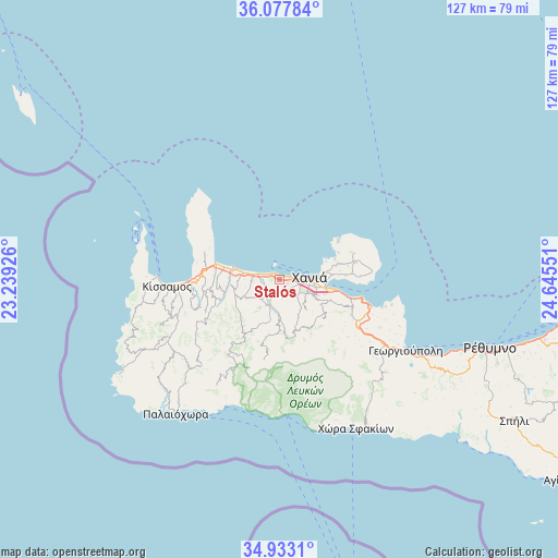
Stalós GPS coordinates[2]
35° 30' 27.036" North, 23° 56' 32.568" East
| Map corner | latitude | longitude |
|---|---|---|
| Upper-left | 36.07784°, | 23.23926° |
| Center: | 35.50751°, | 23.94238° |
| Lower-right: | 34.9331°, | 24.64551° |
| Map W x H: | 127.3×127.3 km | = 79.1×79.1mi |
| max Lat: | 41.72048° ⇑94.2% North |
| Stalós: | 35.50751° |
| min Lat: | ⇓5.8% South 34.8346° |
| min Long | Stalós | max Long |
| 19.40494° | 23.94238° | 29.59361° |
| W 77.1%⇐ | ⇒22.9% E |
Elevation
Elevation of Stalós is 42 m = 138 ft, and this is 126.9 m = 416 ft below average elevation for this country.
| Max E: |
1439 m = 4721 ft | 63.6% |
| Avg. | 168.9 m = 554 ft | |
| Stalós | 42 m = 138 ft | |
Min E: |
0 m = 0 ft | 36.4% |
See also: Greece elevation on elevation.city.
Geographical zone
Stalós is located in North temperate zone (between Tropic of Cancer and the Arctic Circle). Distance of this Northern Tropic circle is 1342.1 km =833.9 mi to South.| Distance of | km | miles | from Stalós |
|---|---|---|---|
| North Pole | 6059 | 3764.9 | to North |
| Arctic Circle | 3453.1 | 2145.7 | to North |
| Tropic Cancer | 1342.1 | 833.9 | to South |
| Equator | 3948.1 | 2453.2 | to South |


Nearby cities:
15 places around Stalós: (largest is in red/bold)
• Agía Marína
1.8 km =1.1 mi,  308°
308°
• Chaniá
7.9 km =4.9 mi,  86°
86°
• Darátsos
3.1 km =1.9 mi,  106°
106°
• Galatás
2.1 km =1.3 mi,  117°
117°
• Geráni
5.9 km =3.7 mi,  280°
280°
• Kolympári
15.2 km =9.4 mi, 284°
• Mourniés
6.9 km =4.3 mi, 113°
• Mouzourás
19.6 km =12.2 mi,  79°
79°
• Nerokoúros
9.5 km =5.9 mi, 111°
• Perivólia
5.3 km =3.3 mi, 118°
• Pithári
13.1 km =8.1 mi, 85°
• Soúda
12.1 km =7.5 mi,  100°
100°
• Stérnes
18.4 km =11.4 mi, 88°
• Tavronítis
11.3 km =7 mi, 282°
• Tsikalariá
11.4 km =7.1 mi, 107°
Sources, notices
• [Note1] Compared only with cities in Greece existing in our database
• [Src1] Map data: © OpenStreetMap contributors (CC-BY-SA)
• [Src2] Other city data from geonames.org with taken over terms of usage.
• [Src3] Geographical zone / Annual Mean Temperature by Robert A. Rohde @ Wikipedia
