Galatás geodata
Galatás (Crete) is a populated place; located in Greece in Europe/Athens (GMT+3) time zone. With population of 3,166 people, there are 331 cities with bigger population in this country. Compared to other cities in Greece, 94.3% of cities are located further ↑North; 77.7% of cities are located further ←West and 51.8% of cities have lower elevation than Galatás. Note1


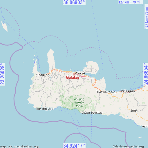
Galatás GPS coordinates[2]
35° 29' 55.104" North, 23° 57' 48.276" East
| Map corner | latitude | longitude |
|---|---|---|
| Upper-left | 36.06903°, | 23.26029° |
| Center: | 35.49864°, | 23.96341° |
| Lower-right: | 34.92417°, | 24.66654° |
| Map W x H: | 127.3×127.3 km | = 79.1×79.1mi |
| max Lat: | 41.72048° ⇑94.3% North |
| Galatás: | 35.49864° |
| min Lat: | ⇓5.7% South 34.8346° |
| min Long | Galatás | max Long |
| 19.40494° | 23.96341° | 29.59361° |
| W 77.7%⇐ | ⇒22.3% E |
Elevation
Elevation of Galatás is 88 m = 289 ft, and this is 80.9 m = 265 ft below average elevation for this country.
| Max E: |
1439 m = 4721 ft | 48.2% |
| Avg. | 168.9 m = 554 ft | |
| Galatás | 88 m = 289 ft | |
Min E: |
0 m = 0 ft | 51.8% |
See also: Greece elevation on elevation.city.
Geographical zone
Galatás is located in North temperate zone (between Tropic of Cancer and the Arctic Circle). Distance of this Northern Tropic circle is 1341.2 km =833.4 mi to South.| Distance of | km | miles | from Galatás |
|---|---|---|---|
| North Pole | 6060 | 3765.5 | to North |
| Arctic Circle | 3454.1 | 2146.3 | to North |
| Tropic Cancer | 1341.2 | 833.4 | to South |
| Equator | 3947.1 | 2452.6 | to South |


Nearby cities:
15 places around Galatás: (largest is in red/bold)
• Agía Marína
3.9 km =2.4 mi,  302°
302°
• Chaniá
6.1 km =3.8 mi,  76°
76°
• Darátsos
1 km =0.6 mi, 84°
• Geráni
8 km =5 mi,  284°
284°
• Kolympári
17.3 km =10.7 mi,  285°
285°
• Mourniés
4.8 km =3 mi,  112°
112°
• Mouzourás
18 km =11.2 mi, 75°
• Nerokoúros
7.4 km =4.6 mi, 110°
• Perivólia
3.2 km =2 mi,  118°
118°
• Pithári
11.3 km =7 mi, 79°
• Soúda
10 km =6.2 mi,  97°
97°
• Stalós
2.1 km =1.3 mi, 297°
• Stérnes
16.6 km =10.3 mi,  85°
85°
• Tavronítis
13.4 km =8.3 mi, 285°
• Tsikalariá
9.3 km =5.8 mi, 105°
Sources, notices
• [Note1] Compared only with cities in Greece existing in our database
• [Src1] Map data: © OpenStreetMap contributors (CC-BY-SA)
• [Src2] Other city data from geonames.org with taken over terms of usage.
• [Src3] Geographical zone / Annual Mean Temperature by Robert A. Rohde @ Wikipedia
