Geráni geodata
Geráni (Crete) is a seat of a third-order administrative division; located in Greece in Europe/Athens (GMT+3) time zone. In our database, there are 1823 cities with bigger population. Compared to other cities in Greece, 93.9% of cities are located further ↑North; 75.6% of cities are located further ←West and 86.6% of cities have higher elevation than Geráni. Note1


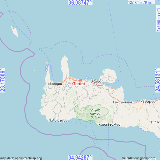
Geráni GPS coordinates[2]
35° 31' 1.956" North, 23° 52' 41.448" East
| Map corner | latitude | longitude |
|---|---|---|
| Upper-left | 36.08747°, | 23.17506° |
| Center: | 35.51721°, | 23.87818° |
| Lower-right: | 34.94287°, | 24.58131° |
| Map W x H: | 127.3×127.3 km | = 79.1×79.1mi |
| max Lat: | 41.72048° ⇑93.9% North |
| Geráni: | 35.51721° |
| min Lat: | ⇓6.1% South 34.8346° |
| min Long | Geráni | max Long |
| 19.40494° | 23.87818° | 29.59361° |
| W 75.6%⇐ | ⇒24.4% E |
Elevation
Elevation of Geráni is 11 m = 36 ft, and this is 157.9 m = 518 ft below average elevation for this country.
| Max E: |
1439 m = 4721 ft | 86.6% |
| Avg. | 168.9 m = 554 ft | |
| Geráni | 11 m = 36 ft | |
Min E: |
0 m = 0 ft | 13.4% |
See also: Greece elevation on elevation.city.
Geographical zone
Geráni is located in North temperate zone (between Tropic of Cancer and the Arctic Circle). Distance of this Northern Tropic circle is 1343.2 km =834.6 mi to South.| Distance of | km | miles | from Geráni |
|---|---|---|---|
| North Pole | 6057.9 | 3764.2 | to North |
| Arctic Circle | 3452 | 2145 | to North |
| Tropic Cancer | 1343.2 | 834.6 | to South |
| Equator | 3949.1 | 2453.9 | to South |


Nearby cities:
15 places around Geráni: (largest is in red/bold)
• Agía Marína
4.4 km =2.7 mi,  89°
89°
• Chaniá
13.7 km =8.5 mi, 92°
• Darátsos
9 km =5.6 mi,  102°
102°
• Galatás
8 km =5 mi, 104°
• Kolympári
9.3 km =5.8 mi,  286°
286°
• Kíssamos
20.5 km =12.7 mi,  262°
262°
• Mourniés
12.8 km =8 mi,  107°
107°
• Nerokoúros
15.3 km =9.5 mi, 107°
• Perivólia
11.1 km =6.9 mi, 108°
• Pithári
18.9 km =11.7 mi, 90°
• Soúda
18 km =11.2 mi, 100°
• Stalós
5.9 km =3.7 mi, 100°
• Stérnes
24.3 km =15.1 mi, 91°
• Tavronítis
5.4 km =3.4 mi, 285°
• Tsikalariá
17.3 km =10.7 mi, 105°
Sources, notices
• [Note1] Compared only with cities in Greece existing in our database
• [Src1] Map data: © OpenStreetMap contributors (CC-BY-SA)
• [Src2] Other city data from geonames.org with taken over terms of usage.
• [Src3] Geographical zone / Annual Mean Temperature by Robert A. Rohde @ Wikipedia
