Mourniés geodata
Mourniés (Crete) is a populated place; located in Greece in Europe/Athens (GMT+3) time zone. With population of 5,318 people, there are 225 cities with bigger population in this country. Compared to other cities in Greece, 94.5% of cities are located further ↑North; 78.9% of cities are located further ←West and 59.6% of cities have higher elevation than Mourniés. Note1


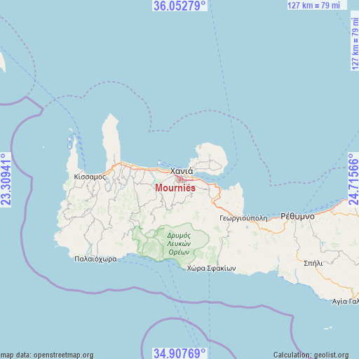
Mourniés GPS coordinates[2]
35° 28' 56.208" North, 24° 0' 45.108" East
| Map corner | latitude | longitude |
|---|---|---|
| Upper-left | 36.05279°, | 23.30941° |
| Center: | 35.48228°, | 24.01253° |
| Lower-right: | 34.90769°, | 24.71566° |
| Map W x H: | 127.3×127.3 km | = 79.1×79.1mi |
| max Lat: | 41.72048° ⇑94.5% North |
| Mourniés: | 35.48228° |
| min Lat: | ⇓5.5% South 34.8346° |
| min Long | Mourniés | max Long |
| 19.40494° | 24.01253° | 29.59361° |
| W 78.9%⇐ | ⇒21.1% E |
Elevation
Elevation of Mourniés is 51 m = 167 ft, and this is 117.9 m = 387 ft below average elevation for this country.
| Max E: |
1439 m = 4721 ft | 59.6% |
| Avg. | 168.9 m = 554 ft | |
| Mourniés | 51 m = 167 ft | |
Min E: |
0 m = 0 ft | 40.4% |
See also: Greece elevation on elevation.city.
Geographical zone
Mourniés is located in North temperate zone (between Tropic of Cancer and the Arctic Circle). Distance of this Northern Tropic circle is 1339.3 km =832.2 mi to South.| Distance of | km | miles | from Mourniés |
|---|---|---|---|
| North Pole | 6061.8 | 3766.6 | to North |
| Arctic Circle | 3455.9 | 2147.4 | to North |
| Tropic Cancer | 1339.3 | 832.2 | to South |
| Equator | 3945.3 | 2451.5 | to South |


Nearby cities:
15 places around Mourniés: (largest is in red/bold)
• Agía Marína
8.7 km =5.4 mi,  296°
296°
• Chaniá
3.6 km =2.2 mi,  25°
25°
• Darátsos
3.9 km =2.4 mi, 299°
• Galatás
4.8 km =3 mi,  292°
292°
• Geráni
12.8 km =8 mi, 287°
• Kalýves
15.1 km =9.4 mi,  103°
103°
• Mouzourás
14.4 km =8.9 mi,  64°
64°
• Nerokoúros
2.6 km =1.6 mi,  106°
106°
• Néo Chorío
13.5 km =8.4 mi,  119°
119°
• Perivólia
1.7 km =1.1 mi,  279°
279°
• Pithári
7.7 km =4.8 mi, 60°
• Soúda
5.5 km =3.4 mi,  84°
84°
• Stalós
6.9 km =4.3 mi, 293°
• Stérnes
12.5 km =7.8 mi, 75°
• Tsikalariá
4.6 km =2.9 mi, 98°
Sources, notices
• [Note1] Compared only with cities in Greece existing in our database
• [Src1] Map data: © OpenStreetMap contributors (CC-BY-SA)
• [Src2] Other city data from geonames.org with taken over terms of usage.
• [Src3] Geographical zone / Annual Mean Temperature by Robert A. Rohde @ Wikipedia
