Spétses geodata
Spétses (Attica) is a seat of a third-order administrative division; located in Greece in Europe/Athens (GMT+3) time zone. With population of 4,001 people, there are 282 cities with bigger population in this country. Compared to other cities in Greece, 87.9% of cities are located further ↑North; 58% of cities are located further ←West and 83.9% of cities have higher elevation than Spétses. Note1


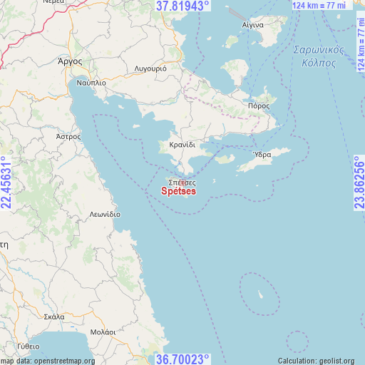
Spétses GPS coordinates[2]
37° 15' 42.876" North, 23° 9' 33.948" East
| Map corner | latitude | longitude |
|---|---|---|
| Upper-left | 37.81943°, | 22.45631° |
| Center: | 37.26191°, | 23.15943° |
| Lower-right: | 36.70023°, | 23.86256° |
| Map W x H: | 124.4×124.4 km | = 77.3×77.3mi |
| max Lat: | 41.72048° ⇑87.9% North |
| Spétses: | 37.26191° |
| min Lat: | ⇓12.1% South 34.8346° |
| min Long | Spétses | max Long |
| 19.40494° | 23.15943° | 29.59361° |
| W 58%⇐ | ⇒42% E |
Elevation
Elevation of Spétses is 14 m = 46 ft, and this is 154.9 m = 508 ft below average elevation for this country.
| Max E: |
1439 m = 4721 ft | 83.9% |
| Avg. | 168.9 m = 554 ft | |
| Spétses | 14 m = 46 ft | |
Min E: |
0 m = 0 ft | 16.1% |
See also: Greece elevation on elevation.city.
Geographical zone
Spétses is located in North temperate zone (between Tropic of Cancer and the Arctic Circle). Distance of this Northern Tropic circle is 1537.2 km =955.2 mi to South.| Distance of | km | miles | from Spétses |
|---|---|---|---|
| North Pole | 5863.9 | 3643.7 | to North |
| Arctic Circle | 3258 | 2024.4 | to North |
| Tropic Cancer | 1537.2 | 955.2 | to South |
| Equator | 4143.1 | 2574.4 | to South |


Nearby cities:
15 places around Spétses: (largest is in red/bold)
• Dídyma
22.3 km =13.9 mi,  2°
2°
• Ermióni
15.7 km =9.8 mi,  29°
29°
• Galatás
36.5 km =22.7 mi,  44°
44°
• Iliókastron
22.4 km =13.9 mi, 25°
• Kalloní
32.8 km =20.4 mi,  20°
20°
• Koilás
17 km =10.6 mi,  349°
349°
• Kranídi
13.1 km =8.1 mi, 0°
• Leonídio
28.7 km =17.8 mi,  248°
248°
• Paralía Tyroú
26.7 km =16.6 mi,  266°
266°
• Poúlithra
29.6 km =18.4 mi,  235°
235°
• Póros
37.1 km =23.1 mi, 44°
• Pórto Chéli
7.5 km =4.7 mi, 349°
• Troizína
31.8 km =19.8 mi, 34°
• Ágios Andréas
36.1 km =22.4 mi,  284°
284°
• Ýdra
28.8 km =17.9 mi,  70°
70°
Sources, notices
• [Note1] Compared only with cities in Greece existing in our database
• [Src1] Map data: © OpenStreetMap contributors (CC-BY-SA)
• [Src2] Other city data from geonames.org with taken over terms of usage.
• [Src3] Geographical zone / Annual Mean Temperature by Robert A. Rohde @ Wikipedia
