Politiká geodata
Politiká (Central Greece) is a populated place; located in Greece in Europe/Athens (GMT+3) time zone. With population of 1,498 people, there are 662 cities with bigger population in this country. Compared to other cities in Greece, 60% of cities are located further ↑North; 65.5% of cities are located further ←West and 60.9% of cities have higher elevation than Politiká. Note1
Administrative division(s):
- Level 1: Central Greece
- Level 2: Nomós Evvoías
- Level 3: Dimos Dirfys-Messapia


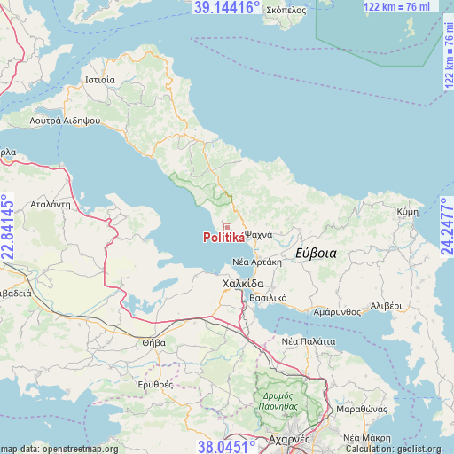
Politiká GPS coordinates[2]
38° 35' 48.228" North, 23° 32' 40.452" East
| Map corner | latitude | longitude |
|---|---|---|
| Upper-left | 39.14416°, | 22.84145° |
| Center: | 38.59673°, | 23.54457° |
| Lower-right: | 38.0451°, | 24.2477° |
| Map W x H: | 122.2×122.2 km | = 75.9×75.9mi |
| max Lat: | 41.72048° ⇑60% North |
| Politiká: | 38.59673° |
| min Lat: | ⇓40% South 34.8346° |
| min Long | Politiká | max Long |
| 19.40494° | 23.54457° | 29.59361° |
| W 65.5%⇐ | ⇒34.5% E |
Elevation
Elevation of Politiká is 47 m = 154 ft, and this is 121.9 m = 400 ft below average elevation for this country.
| Max E: |
1439 m = 4721 ft | 60.9% |
| Avg. | 168.9 m = 554 ft | |
| Politiká | 47 m = 154 ft | |
Min E: |
0 m = 0 ft | 39.1% |
See also: Greece elevation on elevation.city.
Geographical zone
Politiká is located in North temperate zone (between Tropic of Cancer and the Arctic Circle). Distance of this Northern Tropic circle is 1685.6 km =1047.4 mi to South.| Distance of | km | miles | from Politiká |
|---|---|---|---|
| North Pole | 5715.5 | 3551.4 | to North |
| Arctic Circle | 3109.6 | 1932.2 | to North |
| Tropic Cancer | 1685.6 | 1047.4 | to South |
| Equator | 4291.6 | 2666.7 | to South |


Nearby cities:
15 places around Politiká: (largest is in red/bold)
• Afrátion
20.3 km =12.6 mi,  142°
142°
• Chalkída
15.7 km =9.8 mi,  161°
161°
• Dhrosiá
12.5 km =7.8 mi,  178°
178°
• Fílla
21 km =13 mi,  145°
145°
• Kastélla
8.1 km =5 mi,  111°
111°
• Ksyróvrisi
14.9 km =9.3 mi,  170°
170°
• Loukísia
15.5 km =9.6 mi,  212°
212°
• Makrikápa
18 km =11.2 mi,  82°
82°
• Mikrón Vathí
17.9 km =11.1 mi, 166°
• Mytikas
19.5 km =12.1 mi, 150°
• Néa Artáki
11.5 km =7.1 mi, 137°
• Néa Lámpsakos
19.2 km =11.9 mi, 157°
• Paralía Vathéos
21 km =13 mi, 163°
• Prokópi
16 km =9.9 mi,  342°
342°
• Psachná
8.8 km =5.5 mi,  103°
103°
Sources, notices
• [Note1] Compared only with cities in Greece existing in our database
• [Src1] Map data: © OpenStreetMap contributors (CC-BY-SA)
• [Src2] Other city data from geonames.org with taken over terms of usage.
• [Src3] Geographical zone / Annual Mean Temperature by Robert A. Rohde @ Wikipedia
