Prokópi geodata
Prokópi (Central Greece) is a populated place; located in Greece in Europe/Athens (GMT+3) time zone. With population of 1,108 people, there are 913 cities with bigger population in this country. Compared to other cities in Greece, 58.2% of cities are located further ↑North; 64.4% of cities are located further ←West and 56.2% of cities have higher elevation than Prokópi. Note1
Administrative division(s):
- Level 1: Central Greece
- Level 2: Nomós Evvoías
- Level 3: Dimos Mantoudi-Limni-Agia Anna


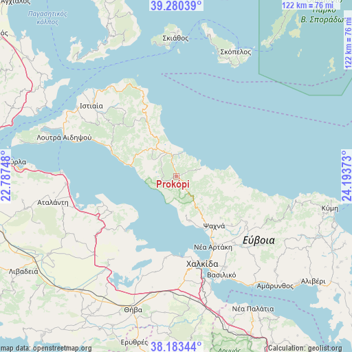
Prokópi GPS coordinates[2]
38° 44' 2.472" North, 23° 29' 26.16" East
| Map corner | latitude | longitude |
|---|---|---|
| Upper-left | 39.28039°, | 22.78748° |
| Center: | 38.73402°, | 23.4906° |
| Lower-right: | 38.18344°, | 24.19373° |
| Map W x H: | 122×122 km | = 75.8×75.8mi |
| max Lat: | 41.72048° ⇑58.2% North |
| Prokópi: | 38.73402° |
| min Lat: | ⇓41.8% South 34.8346° |
| min Long | Prokópi | max Long |
| 19.40494° | 23.4906° | 29.59361° |
| W 64.4%⇐ | ⇒35.6% E |
Elevation
Elevation of Prokópi is 62 m = 203 ft, and this is 106.9 m = 351 ft below average elevation for this country.
| Max E: |
1439 m = 4721 ft | 56.2% |
| Avg. | 168.9 m = 554 ft | |
| Prokópi | 62 m = 203 ft | |
Min E: |
0 m = 0 ft | 43.8% |
See also: Greece elevation on elevation.city.
Geographical zone
Prokópi is located in North temperate zone (between Tropic of Cancer and the Arctic Circle). Distance of this Northern Tropic circle is 1700.9 km =1056.9 mi to South.| Distance of | km | miles | from Prokópi |
|---|---|---|---|
| North Pole | 5700.2 | 3541.9 | to North |
| Arctic Circle | 3094.4 | 1922.8 | to North |
| Tropic Cancer | 1700.9 | 1056.9 | to South |
| Equator | 4306.8 | 2676.1 | to South |


Nearby cities:
15 places around Prokópi: (largest is in red/bold)
• Agía Ánna
16 km =9.9 mi,  330°
330°
• Dhrosiá
28.2 km =17.5 mi,  169°
169°
• Kastélla
21.9 km =13.6 mi,  146°
146°
• Ksyróvrisi
30.8 km =19.1 mi, 166°
• Loukísia
28.5 km =17.7 mi,  187°
187°
• Lárimna
25.9 km =16.1 mi,  223°
223°
• Límni
15.5 km =9.6 mi,  283°
283°
• Makrikápa
26 km =16.2 mi,  120°
120°
• Malesína
25.5 km =15.8 mi,  240°
240°
• Mantoúdi
7.2 km =4.5 mi,  352°
352°
• Martínon
30.2 km =18.8 mi,  232°
232°
• Néa Artáki
26.8 km =16.7 mi, 152°
• Politiká
16 km =9.9 mi,  162°
162°
• Psachná
21.8 km =13.5 mi,  142°
142°
• Roviés
24 km =14.9 mi,  290°
290°
Sources, notices
• [Note1] Compared only with cities in Greece existing in our database
• [Src1] Map data: © OpenStreetMap contributors (CC-BY-SA)
• [Src2] Other city data from geonames.org with taken over terms of usage.
• [Src3] Geographical zone / Annual Mean Temperature by Robert A. Rohde @ Wikipedia
