Makrikápa geodata
Makrikápa (Central Greece) is a populated place; located in Greece in Europe/Athens (GMT+3) time zone. With population of 878 people, there are 1162 cities with bigger population in this country. Compared to other cities in Greece, 59.6% of cities are located further ↑North; 71.3% of cities are located further ←West and 82.7% of cities have lower elevation than Makrikápa. Note1
Administrative division(s):
- Level 1: Central Greece
- Level 2: Nomós Evvoías
- Level 3: Dimos Dirfys-Messapia


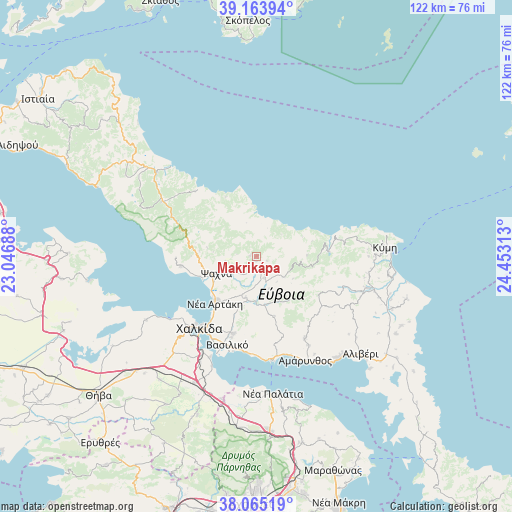
Makrikápa GPS coordinates[2]
38° 37' 0.012" North, 23° 45' 0" East
| Map corner | latitude | longitude |
|---|---|---|
| Upper-left | 39.16394°, | 23.04688° |
| Center: | 38.61667°, | 23.75° |
| Lower-right: | 38.06519°, | 24.45313° |
| Map W x H: | 122.2×122.2 km | = 75.9×75.9mi |
| max Lat: | 41.72048° ⇑59.6% North |
| Makrikápa: | 38.61667° |
| min Lat: | ⇓40.4% South 34.8346° |
| min Long | Makrikápa | max Long |
| 19.40494° | 23.75° | 29.59361° |
| W 71.3%⇐ | ⇒28.7% E |
Elevation
Elevation of Makrikápa is 327 m = 1073 ft, and this is 158.1 m = 519 ft above average elevation for this country.
| Max E: |
1439 m = 4721 ft | 17.3% |
| Makrikápa | 327 m 1073 ft | |
| Avg. | 168.9 m = 554 ft | |
Min E: |
0 m = 0 ft | 82.7% |
See also: Greece elevation on elevation.city.
Geographical zone
Makrikápa is located in North temperate zone (between Tropic of Cancer and the Arctic Circle). Distance of this Northern Tropic circle is 1687.9 km =1048.8 mi to South.| Distance of | km | miles | from Makrikápa |
|---|---|---|---|
| North Pole | 5713.3 | 3550.1 | to North |
| Arctic Circle | 3107.4 | 1930.8 | to North |
| Tropic Cancer | 1687.9 | 1048.8 | to South |
| Equator | 4293.8 | 2668 | to South |


Nearby cities:
15 places around Makrikápa: (largest is in red/bold)
• Afrátion
19.1 km =11.9 mi,  196°
196°
• Chalkída
21.3 km =13.2 mi,  216°
216°
• Dhrosiá
22.9 km =14.2 mi,  230°
230°
• Fílla
20.3 km =12.6 mi, 196°
• Kastélla
11.5 km =7.1 mi,  243°
243°
• Ksyróvrisi
22.9 km =14.2 mi, 222°
• Magoúla
23.6 km =14.7 mi,  164°
164°
• Mytikas
21 km =13 mi, 203°
• Néa Artáki
14.8 km =9.2 mi, 223°
• Néa Lámpsakos
22.6 km =14 mi,  207°
207°
• Politiká
18 km =11.2 mi,  262°
262°
• Psachná
10.2 km =6.3 mi,  245°
245°
• Vasilikón
22.3 km =13.9 mi, 197°
• Yimnón
22.8 km =14.2 mi,  149°
149°
• Áyios Nikólaos
23.6 km =14.7 mi, 202°
Sources, notices
• [Note1] Compared only with cities in Greece existing in our database
• [Src1] Map data: © OpenStreetMap contributors (CC-BY-SA)
• [Src2] Other city data from geonames.org with taken over terms of usage.
• [Src3] Geographical zone / Annual Mean Temperature by Robert A. Rohde @ Wikipedia
