Ágios Ioánnis geodata
Ágios Ioánnis (Epirus) is a populated place; located in Greece in Europe/Athens (GMT+3) time zone. With population of 821 people, there are 1242 cities with bigger population in this country. Compared to other cities in Greece, 62.8% of cities are located further ↓South; 93.6% of cities are located further →East and 89.4% of cities have lower elevation than Ágios Ioánnis. Note1


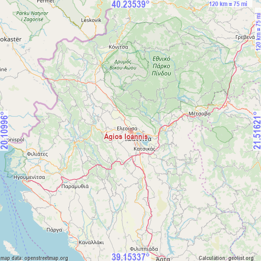
Ágios Ioánnis GPS coordinates[2]
39° 41' 47.4" North, 20° 48' 47.088" East
| Map corner | latitude | longitude |
|---|---|---|
| Upper-left | 40.23539°, | 20.10996° |
| Center: | 39.6965°, | 20.81308° |
| Lower-right: | 39.15337°, | 21.51621° |
| Map W x H: | 120.3×120.3 km | = 74.8×74.8mi |
| max Lat: | 41.72048° ⇑37.2% North |
| Ágios Ioánnis: | 39.6965° |
| min Lat: | ⇓62.8% South 34.8346° |
| min Long | Ágios Ioánnis | max Long |
| 19.40494° | 20.81308° | 29.59361° |
| W 6.4%⇐ | ⇒93.6% E |
Elevation
Elevation of Ágios Ioánnis is 500 m = 1640 ft, and this is 331.1 m = 1086 ft above average elevation for this country.
| Max E: |
1439 m = 4721 ft | 10.6% |
| Ágios Ioánnis | 500 m 1640 ft | |
| Avg. | 168.9 m = 554 ft | |
Min E: |
0 m = 0 ft | 89.4% |
See also: Greece elevation on elevation.city.
Geographical zone
Ágios Ioánnis is located in North temperate zone (between Tropic of Cancer and the Arctic Circle). Distance of this Northern Tropic circle is 1807.9 km =1123.4 mi to South.| Distance of | km | miles | from Ágios Ioánnis |
|---|---|---|---|
| North Pole | 5593.2 | 3475.5 | to North |
| Arctic Circle | 2987.3 | 1856.2 | to North |
| Tropic Cancer | 1807.9 | 1123.4 | to South |
| Equator | 4413.8 | 2742.6 | to South |


Nearby cities:
15 places around Ágios Ioánnis: (largest is in red/bold)
• Amfithéa
4.5 km =2.8 mi,  97°
97°
• Eksochí
1.3 km =0.8 mi,  141°
141°
• Eleoúsa
2.1 km =1.3 mi,  301°
301°
• Ioánnina
4.8 km =3 mi, 136°
• Kardamítsia
2.1 km =1.3 mi,  164°
164°
• Káto Mármara
6.1 km =3.8 mi,  167°
167°
• Káto Neochorópoulo
6.7 km =4.2 mi, 159°
• Mármara
4.8 km =3 mi,  197°
197°
• Pentéli
4 km =2.5 mi,  149°
149°
• Pérama
2.9 km =1.8 mi, 97°
• Stavráki
4.5 km =2.8 mi, 174°
• Tsiflikópoulo
5 km =3.1 mi, 153°
• Velissários
5.6 km =3.5 mi, 156°
• Vounoplagiá
2.4 km =1.5 mi,  256°
256°
• Zoodóchos
4.2 km =2.6 mi, 262°
Sources, notices
• [Note1] Compared only with cities in Greece existing in our database
• [Src1] Map data: © OpenStreetMap contributors (CC-BY-SA)
• [Src2] Other city data from geonames.org with taken over terms of usage.
• [Src3] Geographical zone / Annual Mean Temperature by Robert A. Rohde @ Wikipedia
