Mármara geodata
Mármara (Epirus) is a populated place; located in Greece in Europe/Athens (GMT+3) time zone. With population of 598 people, there are 1582 cities with bigger population in this country. Compared to other cities in Greece, 61.5% of cities are located further ↓South; 93.9% of cities are located further →East and 97.5% of cities have lower elevation than Mármara. Note1


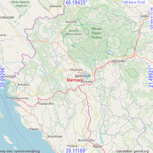
Mármara GPS coordinates[2]
39° 39' 18.504" North, 20° 47' 45.888" East
| Map corner | latitude | longitude |
|---|---|---|
| Upper-left | 40.19435°, | 20.09296° |
| Center: | 39.65514°, | 20.79608° |
| Lower-right: | 39.11169°, | 21.49921° |
| Map W x H: | 120.4×120.4 km | = 74.8×74.8mi |
| max Lat: | 41.72048° ⇑38.5% North |
| Mármara: | 39.65514° |
| min Lat: | ⇓61.5% South 34.8346° |
| min Long | Mármara | max Long |
| 19.40494° | 20.79608° | 29.59361° |
| W 6.1%⇐ | ⇒93.9% E |
Elevation
Elevation of Mármara is 812 m = 2664 ft, and this is 643.1 m = 2110 ft above average elevation for this country.
| Max E: |
1439 m = 4721 ft | 2.5% |
| Mármara | 812 m 2664 ft | |
| Avg. | 168.9 m = 554 ft | |
Min E: |
0 m = 0 ft | 97.5% |
See also: Greece elevation on elevation.city.
Geographical zone
Mármara is located in North temperate zone (between Tropic of Cancer and the Arctic Circle). Distance of this Northern Tropic circle is 1803.3 km =1120.5 mi to South.| Distance of | km | miles | from Mármara |
|---|---|---|---|
| North Pole | 5597.8 | 3478.3 | to North |
| Arctic Circle | 2991.9 | 1859.1 | to North |
| Tropic Cancer | 1803.3 | 1120.5 | to South |
| Equator | 4409.2 | 2739.7 | to South |


Nearby cities:
15 places around Mármara: (largest is in red/bold)
• Eksochí
4.2 km =2.6 mi,  32°
32°
• Eleoúsa
5.7 km =3.5 mi,  356°
356°
• Ioánnina
4.9 km =3 mi,  77°
77°
• Kardamítsia
3.3 km =2.1 mi,  38°
38°
• Káto Mármara
3.1 km =1.9 mi,  116°
116°
• Káto Neochorópoulo
4.2 km =2.6 mi,  113°
113°
• Neochorópoulo
4.7 km =2.9 mi,  134°
134°
• Pentéli
3.7 km =2.3 mi,  71°
71°
• Pérama
6.1 km =3.8 mi,  45°
45°
• Stavráki
1.9 km =1.2 mi,  86°
86°
• Tsiflikópoulo
3.7 km =2.3 mi, 88°
• Velissários
3.7 km =2.3 mi,  98°
98°
• Vounoplagiá
4.1 km =2.5 mi,  347°
347°
• Zoodóchos
4.9 km =3 mi,  326°
326°
• Ágios Ioánnis
4.8 km =3 mi,  17°
17°
Sources, notices
• [Note1] Compared only with cities in Greece existing in our database
• [Src1] Map data: © OpenStreetMap contributors (CC-BY-SA)
• [Src2] Other city data from geonames.org with taken over terms of usage.
• [Src3] Geographical zone / Annual Mean Temperature by Robert A. Rohde @ Wikipedia
