Pálairos geodata
Pálairos (West Greece) is a populated place; located in Greece in Europe/Athens (GMT+3) time zone. With population of 2,589 people, there are 402 cities with bigger population in this country. Compared to other cities in Greece, 57.7% of cities are located further ↑North; 91.7% of cities are located further →East and 71.4% of cities have higher elevation than Pálairos. Note1
Administrative division(s):
- Level 1: West Greece
- Level 2: Nomós Aitolías kai Akarnanías
- Level 3: Dimos Aktio-Vonitsa


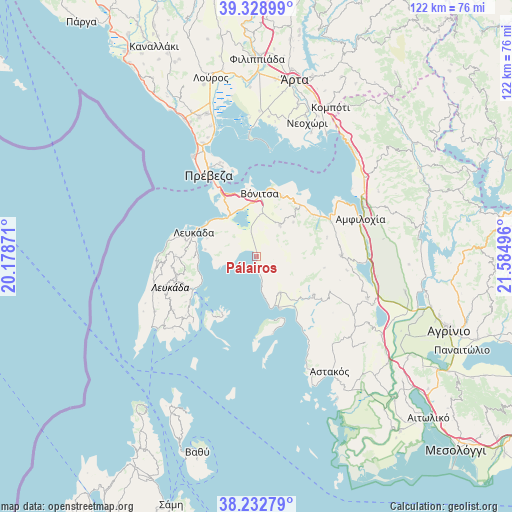
Pálairos GPS coordinates[2]
38° 46' 58.8" North, 20° 52' 54.588" East
| Map corner | latitude | longitude |
|---|---|---|
| Upper-left | 39.32899°, | 20.17871° |
| Center: | 38.783°, | 20.88183° |
| Lower-right: | 38.23279°, | 21.58496° |
| Map W x H: | 121.9×121.9 km | = 75.7×75.7mi |
| max Lat: | 41.72048° ⇑57.7% North |
| Pálairos: | 38.783° |
| min Lat: | ⇓42.3% South 34.8346° |
| min Long | Pálairos | max Long |
| 19.40494° | 20.88183° | 29.59361° |
| W 8.3%⇐ | ⇒91.7% E |
Elevation
Elevation of Pálairos is 29 m = 95 ft, and this is 139.9 m = 459 ft below average elevation for this country.
| Max E: |
1439 m = 4721 ft | 71.4% |
| Avg. | 168.9 m = 554 ft | |
| Pálairos | 29 m = 95 ft | |
Min E: |
0 m = 0 ft | 28.6% |
See also: Greece elevation on elevation.city.
Geographical zone
Pálairos is located in North temperate zone (between Tropic of Cancer and the Arctic Circle). Distance of this Northern Tropic circle is 1706.3 km =1060.2 mi to South.| Distance of | km | miles | from Pálairos |
|---|---|---|---|
| North Pole | 5694.8 | 3538.6 | to North |
| Arctic Circle | 3088.9 | 1919.4 | to North |
| Tropic Cancer | 1706.3 | 1060.2 | to South |
| Equator | 4312.3 | 2679.5 | to South |


Nearby cities:
15 places around Pálairos: (largest is in red/bold)
• Archontochóri
16.4 km =10.2 mi,  123°
123°
• Kandíla
10.3 km =6.4 mi,  146°
146°
• Kariótai
14.6 km =9.1 mi,  276°
276°
• Lefkáda
16.2 km =10.1 mi,  288°
288°
• Ligia
14.1 km =8.8 mi,  271°
271°
• Monastiráki
9.3 km =5.8 mi,  35°
35°
• Mýtikas
13.8 km =8.6 mi,  156°
156°
• Nidhríon
16.7 km =10.4 mi,  240°
240°
• Nikiána
14.4 km =8.9 mi,  259°
259°
• Paliámpela
15.4 km =9.6 mi,  23°
23°
• Plagiá
12.4 km =7.7 mi, 278°
• Thýrio
11.9 km =7.4 mi,  46°
46°
• Trýfos
17.3 km =10.7 mi,  75°
75°
• Vónitsa
14.8 km =9.2 mi,  1°
1°
• Ágios Nikólaos
11.7 km =7.3 mi,  324°
324°
Sources, notices
• [Note1] Compared only with cities in Greece existing in our database
• [Src1] Map data: © OpenStreetMap contributors (CC-BY-SA)
• [Src2] Other city data from geonames.org with taken over terms of usage.
• [Src3] Geographical zone / Annual Mean Temperature by Robert A. Rohde @ Wikipedia
