Vónitsa geodata
Vónitsa (West Greece) is a seat of a third-order administrative division; located in Greece in Europe/Athens (GMT+3) time zone. With population of 4,703 people, there are 249 cities with bigger population in this country. Compared to other cities in Greece, 55.3% of cities are located further ↑North; 91.5% of cities are located further →East and 100% of cities have higher elevation than Vónitsa. Note1
Administrative division(s):
- Level 1: West Greece
- Level 2: Nomós Aitolías kai Akarnanías
- Level 3: Dimos Aktio-Vonitsa


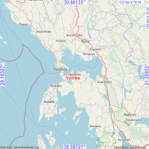
Vónitsa GPS coordinates[2]
38° 54' 59.004" North, 20° 53' 11.004" East
| Map corner | latitude | longitude |
|---|---|---|
| Upper-left | 39.46135°, | 20.18327° |
| Center: | 38.91639°, | 20.88639° |
| Lower-right: | 38.36721°, | 21.58952° |
| Map W x H: | 121.7×121.7 km | = 75.6×75.6mi |
| max Lat: | 41.72048° ⇑55.3% North |
| Vónitsa: | 38.91639° |
| min Lat: | ⇓44.7% South 34.8346° |
| min Long | Vónitsa | max Long |
| 19.40494° | 20.88639° | 29.59361° |
| W 8.5%⇐ | ⇒91.5% E |
Elevation
Elevation of Vónitsa is 0 m = 0 ft, and this is 168.9 m = 554 ft below average elevation for this country.
| Max E: |
1439 m = 4721 ft | 100% |
| Avg. | 168.9 m = 554 ft | |
| Vónitsa | 0 m = 0 ft | |
Min E: |
0 m = 0 ft | 0% |
See also: Greece elevation on elevation.city.
Geographical zone
Vónitsa is located in North temperate zone (between Tropic of Cancer and the Arctic Circle). Distance of this Northern Tropic circle is 1721.2 km =1069.5 mi to South.| Distance of | km | miles | from Vónitsa |
|---|---|---|---|
| North Pole | 5680 | 3529.4 | to North |
| Arctic Circle | 3074.1 | 1910.2 | to North |
| Tropic Cancer | 1721.2 | 1069.5 | to South |
| Equator | 4327.1 | 2688.7 | to South |


Nearby cities:
15 places around Vónitsa: (largest is in red/bold)
• Anéza
19.2 km =11.9 mi,  9°
9°
• Kariótai
19.8 km =12.3 mi,  228°
228°
• Komméno
19.2 km =11.9 mi,  40°
40°
• Lefkáda
18.4 km =11.4 mi,  238°
238°
• Ligia
20.4 km =12.7 mi, 225°
• Monastiráki
8.9 km =5.5 mi,  145°
145°
• Mýtikas
18 km =11.2 mi,  300°
300°
• Neochóri
20.6 km =12.8 mi,  33°
33°
• Paliámpela
5.7 km =3.5 mi,  96°
96°
• Plagiá
18.2 km =11.3 mi,  224°
224°
• Préveza
12.6 km =7.8 mi,  290°
290°
• Pálairos
14.8 km =9.2 mi,  181°
181°
• Thýrio
10.6 km =6.6 mi,  129°
129°
• Trýfos
19.4 km =12.1 mi,  122°
122°
• Ágios Nikólaos
8.9 km =5.5 mi, 233°
Sources, notices
• [Note1] Compared only with cities in Greece existing in our database
• [Src1] Map data: © OpenStreetMap contributors (CC-BY-SA)
• [Src2] Other city data from geonames.org with taken over terms of usage.
• [Src3] Geographical zone / Annual Mean Temperature by Robert A. Rohde @ Wikipedia
