Oichalía geodata
Oichalía (Thessaly) is a populated place; located in Greece in Europe/Athens (GMT+3) time zone. With population of 3,271 people, there are 326 cities with bigger population in this country. Compared to other cities in Greece, 59.7% of cities are located further ↓South; 72.7% of cities are located further →East and 57.2% of cities have lower elevation than Oichalía. Note1


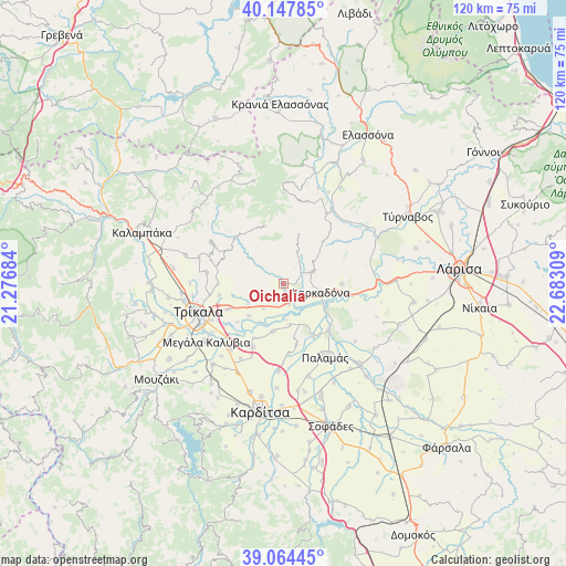
Oichalía GPS coordinates[2]
39° 36' 29.772" North, 21° 58' 47.856" East
| Map corner | latitude | longitude |
|---|---|---|
| Upper-left | 40.14785°, | 21.27684° |
| Center: | 39.60827°, | 21.97996° |
| Lower-right: | 39.06445°, | 22.68309° |
| Map W x H: | 120.5×120.5 km | = 74.9×74.9mi |
| max Lat: | 41.72048° ⇑40.3% North |
| Oichalía: | 39.60827° |
| min Lat: | ⇓59.7% South 34.8346° |
| min Long | Oichalía | max Long |
| 19.40494° | 21.97996° | 29.59361° |
| W 27.3%⇐ | ⇒72.7% E |
Elevation
Elevation of Oichalía is 106 m = 348 ft, and this is 62.9 m = 206 ft below average elevation for this country.
| Max E: |
1439 m = 4721 ft | 42.8% |
| Avg. | 168.9 m = 554 ft | |
| Oichalía | 106 m = 348 ft | |
Min E: |
0 m = 0 ft | 57.2% |
See also: Greece elevation on elevation.city.
Geographical zone
Oichalía is located in North temperate zone (between Tropic of Cancer and the Arctic Circle). Distance of this Northern Tropic circle is 1798.1 km =1117.3 mi to South.| Distance of | km | miles | from Oichalía |
|---|---|---|---|
| North Pole | 5603 | 3481.5 | to North |
| Arctic Circle | 2997.1 | 1862.3 | to North |
| Tropic Cancer | 1798.1 | 1117.3 | to South |
| Equator | 4404 | 2736.5 | to South |


Nearby cities:
15 places around Oichalía: (largest is in red/bold)
• Faneroméni
10.1 km =6.3 mi,  227°
227°
• Farkadóna
7.5 km =4.7 mi,  97°
97°
• Grizáno
6.8 km =4.2 mi,  67°
67°
• Kríni
2.8 km =1.7 mi, 74°
• Marathéa
8.8 km =5.5 mi,  171°
171°
• Megalochóri
13 km =8.1 mi,  245°
245°
• Palaiópyrgos
13.9 km =8.6 mi,  270°
270°
• Patouliá
12.8 km =8 mi, 230°
• Pedinó
10.3 km =6.4 mi,  193°
193°
• Petrotó
2.8 km =1.7 mi,  209°
209°
• Petróporo
6.8 km =4.2 mi,  220°
220°
• Servotá
13.1 km =8.1 mi, 208°
• Taxiárches
8.3 km =5.2 mi,  244°
244°
• Zileftí
14 km =8.7 mi,  260°
260°
• Zárkos
12.3 km =7.6 mi,  89°
89°
Sources, notices
• [Note1] Compared only with cities in Greece existing in our database
• [Src1] Map data: © OpenStreetMap contributors (CC-BY-SA)
• [Src2] Other city data from geonames.org with taken over terms of usage.
• [Src3] Geographical zone / Annual Mean Temperature by Robert A. Rohde @ Wikipedia
